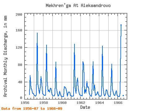
| Point ID: 8856 | Downloads | Plots | Site Data | Code: 70320 |
| Download | |
|---|---|
| Site Descriptor Information | Site Time Series Data |
| Link to all available data | |

|

|
| View: | Statistics | Time Series |
| Units: | m3/s |
| Statistic | Jan | Feb | Mar | Apr | May | Jun | Jul | Aug | Sep | Oct | Nov | Dec | Annual |
|---|---|---|---|---|---|---|---|---|---|---|---|---|---|
| Mean | 8.33 | 6.88 | 7.13 | 22.74 | 109.93 | 28.49 | 17.34 | 17.67 | 20.50 | 24.45 | 19.84 | 11.08 | 283.60 |
| Standard Deviation | 1.27 | 1.04 | 0.77 | 23.81 | 43.66 | 10.03 | 7.00 | 15.97 | 13.78 | 11.77 | 7.27 | 2.61 | 72.23 |
| Min | 6.16 | 5.67 | 5.96 | 7.18 | 28.74 | 13.38 | 10.79 | 6.81 | 7.96 | 12.41 | 11.23 | 6.81 | 181.48 |
| Max | 10.79 | 8.85 | 8.70 | 86.83 | 178.08 | 44.79 | 33.86 | 56.53 | 48.84 | 54.30 | 34.60 | 15.11 | 391.58 |
| Coefficient of Variation | 0.15 | 0.15 | 0.11 | 1.05 | 0.40 | 0.35 | 0.40 | 0.90 | 0.67 | 0.48 | 0.37 | 0.23 | 0.26 |
| Year | Jan | Feb | Mar | Apr | May | Jun | Jul | Aug | Sep | Oct | Nov | Dec | Annual | 1956 | 10.93 | 56.53 | 25.20 | 24.42 | 13.25 | 13.36 | 1957 | 9.04 | 7.87 | 6.88 | 9.47 | 158.52 | 35.78 | 22.87 | 13.22 | 28.34 | 54.30 | 34.60 | 13.49 | 391.58 | 1958 | 10.79 | 8.85 | 8.70 | 9.53 | 130.19 | 43.35 | 17.88 | 21.52 | 16.32 | 26.17 | 24.09 | 12.55 | 327.92 | 1959 | 8.50 | 7.13 | 7.76 | 12.27 | 89.04 | 24.42 | 12.88 | 6.81 | 9.14 | 18.55 | 11.23 | 6.81 | 213.25 | 1960 | 6.16 | 5.76 | 5.96 | 29.05 | 28.74 | 25.40 | 17.27 | 6.88 | 15.15 | 17.13 | 15.60 | 8.30 | 181.48 | 1961 | 7.89 | 6.33 | 7.35 | 7.18 | 132.21 | 26.70 | 13.49 | 39.06 | 48.84 | 25.63 | 14.23 | 10.05 | 336.67 | 1962 | 9.04 | 7.68 | 7.55 | 86.83 | 80.95 | 13.38 | 23.27 | 14.23 | 40.94 | 28.80 | 28.01 | 15.11 | 355.68 | 1963 | 9.11 | 7.19 | 7.22 | 27.94 | 89.72 | 19.65 | 33.86 | 9.58 | 9.79 | 12.41 | 17.30 | 10.72 | 253.06 | 1964 | 7.55 | 6.33 | 6.88 | 10.51 | 127.49 | 28.40 | 10.79 | 7.76 | 11.03 | 22.39 | 20.18 | 11.47 | 268.83 | 1965 | 7.83 | 6.02 | 6.51 | 20.18 | 84.32 | 23.05 | 15.45 | 10.19 | 7.96 | 14.71 | 19.85 | 8.97 | 223.88 | 1966 | 7.35 | 5.67 | 6.54 | 14.43 | 178.08 | 44.79 | 12.01 | 8.57 | 12.80 |
|---|
 Return to R-Arctic Net Home Page