|
|
|||||||||||||||||
| Point ID: 8693 | Downloads | Plots | Site Data | Code: 11610 |
|
|
|||||||||||||||||
| Download | |
|---|---|
| Site Descriptor Information | Site Time Series Data |
| Link to all available data | |
| View: | Time Series | All |
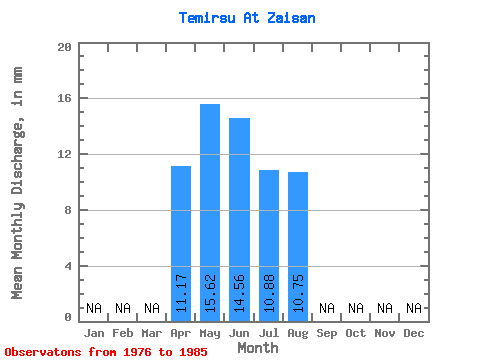
| Units: | m3/s |
| Statistic | Jan | Feb | Mar | Apr | May | Jun | Jul | Aug | Sep | Oct | Nov | Dec | Annual |
|---|---|---|---|---|---|---|---|---|---|---|---|---|---|
| Mean | 11.17 | 15.61 | 14.55 | 10.88 | 10.76 | ||||||||
| Standard Deviation | 10.35 | 12.00 | 11.38 | 9.57 | |||||||||
| Min | 11.17 | 7.42 | 3.99 | 2.88 | 4.12 | ||||||||
| Max | 11.17 | 39.96 | 44.66 | 40.79 | 32.96 | ||||||||
| Coefficient of Variation | 0.66 | 0.82 | 1.05 | 0.89 |
 Return to R-Arctic Net Home Page