|
|
|||||||||||||||||
| Point ID: 8693 | Downloads | Plots | Site Data | Code: 11610 |
|
|
|||||||||||||||||
| Download | |
|---|---|
| Site Descriptor Information | Site Time Series Data |
| Link to all available data | |
|
|
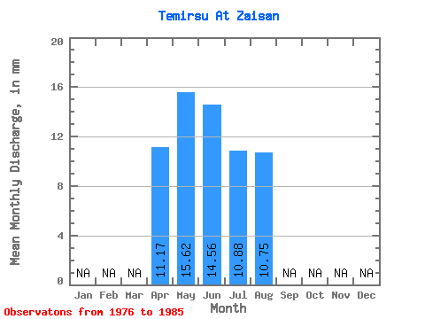
| View: | Statistics | Time Series |
| Units: | m3/s |
| Statistic | Jan | Feb | Mar | Apr | May | Jun | Jul | Aug | Sep | Oct | Nov | Dec | Annual |
|---|---|---|---|---|---|---|---|---|---|---|---|---|---|
| Mean | 11.17 | 15.61 | 14.55 | 10.88 | 10.76 | ||||||||
| Standard Deviation | 10.35 | 12.00 | 11.38 | 9.57 | |||||||||
| Min | 11.17 | 7.42 | 3.99 | 2.88 | 4.12 | ||||||||
| Max | 11.17 | 39.96 | 44.66 | 40.79 | 32.96 | ||||||||
| Coefficient of Variation | 0.66 | 0.82 | 1.05 | 0.89 |
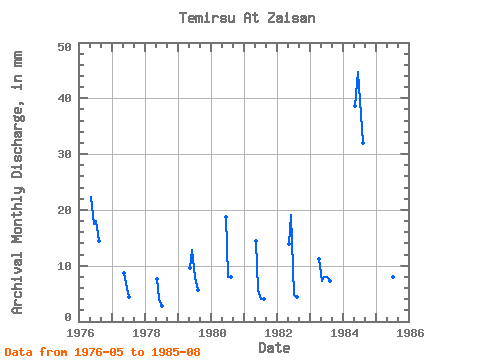
| Year | Jan | Feb | Mar | Apr | May | Jun | Jul | Aug | Sep | Oct | Nov | Dec | Annual | 1976 | 23.07 | 17.55 | 18.54 | 14.83 | 1977 | 9.06 | 5.98 | 4.53 | 1978 | 7.83 | 3.99 | 2.88 | 1979 | 9.89 | 12.76 | 8.24 | 5.77 | 1980 | 18.74 | 8.24 | 8.24 | 1981 | 14.83 | 5.58 | 4.12 | 4.12 | 1982 | 14.42 | 19.14 | 4.94 | 4.53 | 1983 | 11.17 | 7.42 | 7.97 | 8.24 | 7.42 | 1984 | 39.96 | 44.66 | 40.79 | 32.96 | 1985 | 14.01 | 9.17 | 8.24 | 8.24 |
|---|
 Return to R-Arctic Net Home Page