|
|
|||||||||||||||||
| Point ID: 8686 | Downloads | Plots | Site Data | Code: 11603 |
|
|
|||||||||||||||||
| Download | |
|---|---|
| Site Descriptor Information | Site Time Series Data |
| Link to all available data | |
| View: | Time Series | All |
| Units: | m3/s |
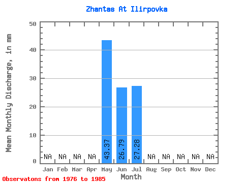
| Statistic | Jan | Feb | Mar | Apr | May | Jun | Jul | Aug | Sep | Oct | Nov | Dec | Annual |
|---|---|---|---|---|---|---|---|---|---|---|---|---|---|
| Mean | 43.40 | 26.78 | 27.24 | ||||||||||
| Standard Deviation | 27.65 | 35.49 | 48.55 | ||||||||||
| Min | 17.99 | 8.22 | 6.00 | ||||||||||
| Max | 96.93 | 114.12 | 146.89 | ||||||||||
| Coefficient of Variation | 0.64 | 1.32 | 1.78 |
 Return to R-Arctic Net Home Page