|
|
|||||||||||||||||
| Point ID: 8686 | Downloads | Plots | Site Data | Code: 11603 |
|
|
|||||||||||||||||
| Download | |
|---|---|
| Site Descriptor Information | Site Time Series Data |
| Link to all available data | |
|
|
| View: | Statistics | Time Series |
| Units: | m3/s |
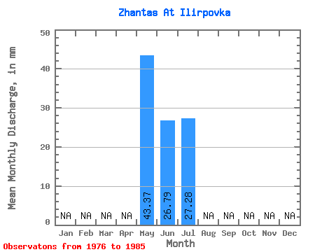
| Statistic | Jan | Feb | Mar | Apr | May | Jun | Jul | Aug | Sep | Oct | Nov | Dec | Annual |
|---|---|---|---|---|---|---|---|---|---|---|---|---|---|
| Mean | 43.40 | 26.78 | 27.24 | ||||||||||
| Standard Deviation | 27.65 | 35.49 | 48.55 | ||||||||||
| Min | 17.99 | 8.22 | 6.00 | ||||||||||
| Max | 96.93 | 114.12 | 146.89 | ||||||||||
| Coefficient of Variation | 0.64 | 1.32 | 1.78 |
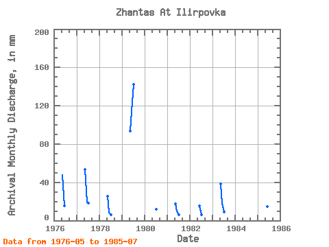
| Year | Jan | Feb | Mar | Apr | May | Jun | Jul | Aug | Sep | Oct | Nov | Dec | Annual | 1976 | 48.96 | 15.47 | 1977 | 54.96 | 19.34 | 18.99 | 1978 | 25.98 | 8.22 | 6.09 | 1979 | 96.93 | 114.12 | 146.89 | 1980 | 11.99 | 1981 | 17.99 | 9.67 | 6.00 | 1982 | 15.47 | 6.00 | 1983 | 39.97 | 17.41 | 8.99 | 1985 | 18.99 | 14.51 | 12.99 |
|---|
 Return to R-Arctic Net Home Page