|
|
|||||||||||||||||
| Point ID: 8681 | Downloads | Plots | Site Data | Code: 11597 |
|
|
|||||||||||||||||
| Download | |
|---|---|
| Site Descriptor Information | Site Time Series Data |
| Link to all available data | |
| View: | Time Series | All |
| Units: | m3/s |
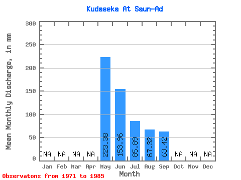
| Statistic | Jan | Feb | Mar | Apr | May | Jun | Jul | Aug | Sep | Oct | Nov | Dec | Annual |
|---|---|---|---|---|---|---|---|---|---|---|---|---|---|
| Mean | 223.41 | 153.91 | 85.81 | 67.37 | 63.36 | ||||||||
| Standard Deviation | 86.15 | 103.06 | 51.04 | 38.56 | 39.51 | ||||||||
| Min | 78.56 | 44.93 | 25.00 | 12.50 | 13.82 | ||||||||
| Max | 373.13 | 452.74 | 217.81 | 164.25 | 164.16 | ||||||||
| Coefficient of Variation | 0.39 | 0.67 | 0.59 | 0.57 | 0.62 |
 Return to R-Arctic Net Home Page