|
|
|||||||||||||||||
| Point ID: 8681 | Downloads | Plots | Site Data | Code: 11597 |
|
|
|||||||||||||||||
| Download | |
|---|---|
| Site Descriptor Information | Site Time Series Data |
| Link to all available data | |
|
|
| View: | Statistics | Time Series |
| Units: | m3/s |
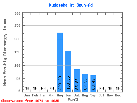
| Statistic | Jan | Feb | Mar | Apr | May | Jun | Jul | Aug | Sep | Oct | Nov | Dec | Annual |
|---|---|---|---|---|---|---|---|---|---|---|---|---|---|
| Mean | 223.41 | 153.91 | 85.81 | 67.37 | 63.36 | ||||||||
| Standard Deviation | 86.15 | 103.06 | 51.04 | 38.56 | 39.51 | ||||||||
| Min | 78.56 | 44.93 | 25.00 | 12.50 | 13.82 | ||||||||
| Max | 373.13 | 452.74 | 217.81 | 164.25 | 164.16 | ||||||||
| Coefficient of Variation | 0.39 | 0.67 | 0.59 | 0.57 | 0.62 |
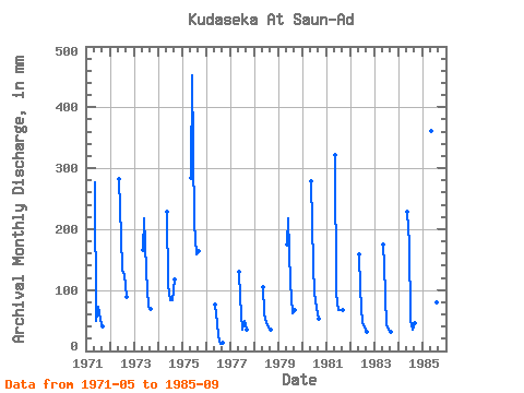
| Year | Jan | Feb | Mar | Apr | May | Jun | Jul | Aug | Sep | Oct | Nov | Dec | Annual | 1971 | 285.65 | 50.11 | 74.98 | 53.56 | 39.74 | 1972 | 291.01 | 186.62 | 137.47 | 128.54 | 88.13 | 1973 | 171.39 | 217.73 | 135.69 | 74.98 | 69.12 | 1974 | 235.66 | 108.86 | 85.70 | 85.70 | 117.50 | 1975 | 292.80 | 452.74 | 217.81 | 164.25 | 164.16 | 1976 | 78.56 | 44.93 | 25.00 | 12.50 | 13.82 | 1977 | 133.90 | 88.13 | 35.71 | 51.77 | 34.56 | 1978 | 108.91 | 62.21 | 46.42 | 39.28 | 34.56 | 1979 | 180.32 | 217.73 | 116.05 | 64.27 | 67.39 | 1980 | 287.44 | 139.97 | 99.98 | 73.20 | 53.57 | 1981 | 332.07 | 93.31 | 69.63 | 69.63 | 67.39 | 1982 | 164.25 | 101.95 | 46.42 | 39.28 | 31.10 | 1983 | 180.32 | 139.97 | 42.85 | 35.71 | 31.10 | 1984 | 235.66 | 176.26 | 53.56 | 35.71 | 44.93 | 1985 | 373.13 | 228.10 | 99.98 | 82.12 | 93.31 |
|---|
 Return to R-Arctic Net Home Page