|
|
|||||||||||||||||
| Point ID: 8627 | Downloads | Plots | Site Data | Code: 11288 |
|
|
|||||||||||||||||
| Download | |
|---|---|
| Site Descriptor Information | Site Time Series Data |
| Link to all available data | |
| View: | Time Series | All |
| Units: | m3/s |
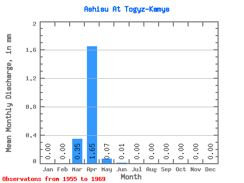
| Statistic | Jan | Feb | Mar | Apr | May | Jun | Jul | Aug | Sep | Oct | Nov | Dec | Annual |
|---|---|---|---|---|---|---|---|---|---|---|---|---|---|
| Mean | 0.00 | 0.00 | 0.35 | 1.66 | 0.07 | 0.01 | 0.00 | 0.00 | 0.00 | 0.00 | 0.00 | 0.00 | 2.36 |
| Standard Deviation | 0.00 | 0.00 | 1.27 | 3.07 | 0.15 | 0.01 | 0.01 | 0.01 | 0.00 | 0.00 | 0.00 | 0.00 | 4.11 |
| Min | 0.00 | 0.00 | 0.00 | 0.01 | 0.00 | 0.00 | 0.00 | 0.00 | 0.00 | 0.00 | 0.00 | 0.00 | 0.01 |
| Max | 0.00 | 0.00 | 4.95 | 11.52 | 0.55 | 0.04 | 0.02 | 0.02 | 0.01 | 0.01 | 0.01 | 0.00 | 12.31 |
| Coefficient of Variation | 3.59 | 1.86 | 2.04 | 1.63 | 1.82 | 2.28 | 2.64 | 2.20 | 2.18 | 1.74 |
 Return to R-Arctic Net Home Page