|
|
|||||||||||||||||
| Point ID: 8627 | Downloads | Plots | Site Data | Code: 11288 |
|
|
|||||||||||||||||
| Download | |
|---|---|
| Site Descriptor Information | Site Time Series Data |
| Link to all available data | |
|
|
| View: | Statistics | Time Series |
| Units: | m3/s |
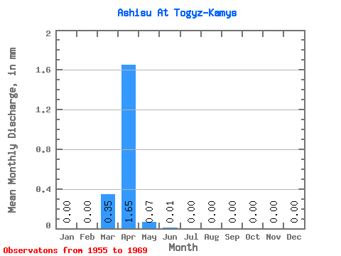
| Statistic | Jan | Feb | Mar | Apr | May | Jun | Jul | Aug | Sep | Oct | Nov | Dec | Annual |
|---|---|---|---|---|---|---|---|---|---|---|---|---|---|
| Mean | 0.00 | 0.00 | 0.35 | 1.66 | 0.07 | 0.01 | 0.00 | 0.00 | 0.00 | 0.00 | 0.00 | 0.00 | 2.36 |
| Standard Deviation | 0.00 | 0.00 | 1.27 | 3.07 | 0.15 | 0.01 | 0.01 | 0.01 | 0.00 | 0.00 | 0.00 | 0.00 | 4.11 |
| Min | 0.00 | 0.00 | 0.00 | 0.01 | 0.00 | 0.00 | 0.00 | 0.00 | 0.00 | 0.00 | 0.00 | 0.00 | 0.01 |
| Max | 0.00 | 0.00 | 4.95 | 11.52 | 0.55 | 0.04 | 0.02 | 0.02 | 0.01 | 0.01 | 0.01 | 0.00 | 12.31 |
| Coefficient of Variation | 3.59 | 1.86 | 2.04 | 1.63 | 1.82 | 2.28 | 2.64 | 2.20 | 2.18 | 1.74 |
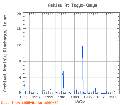
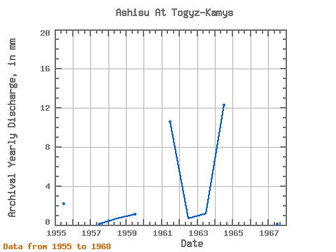
| Year | Jan | Feb | Mar | Apr | May | Jun | Jul | Aug | Sep | Oct | Nov | Dec | Annual | 1955 | 0.00 | 0.00 | 0.00 | 2.18 | 0.02 | 0.00 | 0.00 | 0.00 | 0.00 | 0.00 | 0.00 | 0.00 | 2.23 | 1956 | 0.00 | 0.00 | 0.00 | 0.01 | 0.00 | 0.01 | 0.00 | 0.00 | 0.00 | 0.00 | 0.00 | 0.00 | 0.02 | 1957 | 0.00 | 0.00 | 0.00 | 0.12 | 0.00 | 0.00 | 0.00 | 0.00 | 0.00 | 0.00 | 0.00 | 0.00 | 0.12 | 1958 | 0.00 | 0.00 | 0.00 | 0.73 | 0.00 | 0.00 | 0.00 | 0.00 | 0.00 | 0.00 | 0.00 | 0.00 | 0.74 | 1959 | 0.00 | 0.00 | 0.00 | 1.09 | 0.00 | 0.00 | 0.00 | 0.00 | 0.00 | 0.00 | 0.00 | 0.00 | 1.11 | 1960 | 0.00 | 0.00 | 0.00 | 0.30 | 0.00 | 0.00 | 1961 | 0.00 | 0.00 | 4.95 | 5.54 | 0.10 | 0.01 | 0.01 | 0.01 | 0.00 | 0.00 | 0.00 | 0.00 | 10.60 | 1962 | 0.00 | 0.00 | 0.36 | 0.24 | 0.03 | 0.02 | 0.00 | 0.00 | 0.00 | 0.00 | 0.00 | 0.00 | 0.65 | 1963 | 0.00 | 0.00 | 0.00 | 1.17 | 0.01 | 0.00 | 0.00 | 0.00 | 0.00 | 0.00 | 0.00 | 0.00 | 1.21 | 1964 | 0.00 | 0.00 | 0.00 | 11.52 | 0.55 | 0.04 | 0.02 | 0.01 | 0.01 | 0.01 | 0.00 | 0.00 | 12.31 | 1965 | 0.00 | 0.00 | 0.01 | 0.02 | 0.01 | 0.00 | 0.00 | 0.00 | 0.00 | 0.00 | 0.00 | 0.00 | 0.05 | 1966 | 0.00 | 0.00 | 0.00 | 1.19 | 0.25 | 0.04 | 0.01 | 0.00 | 0.00 | 0.00 | 0.00 | 0.00 | 1.50 | 1967 | 0.00 | 0.00 | 0.00 | 0.07 | 0.01 | 0.00 | 0.01 | 0.02 | 0.00 | 0.01 | 0.01 | 0.00 | 0.12 | 1968 | 0.00 | 0.00 | 0.00 | 0.01 | 0.00 | 0.00 | 0.00 | 0.00 | 0.00 | 0.00 | 0.00 | 0.00 | 0.01 | 1969 | 0.00 | 0.00 | 0.00 | 0.63 | 0.11 |
|---|
 Return to R-Arctic Net Home Page