|
|
|||||||||||||||||
| Point ID: 8528 | Downloads | Plots | Site Data | Code: 10611 |
|
|
|||||||||||||||||
| Download | |
|---|---|
| Site Descriptor Information | Site Time Series Data |
| Link to all available data | |
| View: | Time Series | All |
| Units: | m3/s |
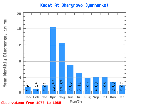
| Statistic | Jan | Feb | Mar | Apr | May | Jun | Jul | Aug | Sep | Oct | Nov | Dec | Annual |
|---|---|---|---|---|---|---|---|---|---|---|---|---|---|
| Mean | 1.64 | 1.25 | 2.01 | 16.47 | 12.51 | 7.05 | 5.11 | 4.00 | 4.08 | 4.04 | 2.83 | 2.06 | 63.05 |
| Standard Deviation | 0.34 | 0.25 | 0.56 | 8.29 | 6.95 | 4.15 | 2.13 | 1.75 | 2.19 | 1.78 | 0.78 | 0.44 | 24.58 |
| Min | 1.00 | 0.97 | 1.57 | 6.20 | 4.56 | 2.48 | 2.56 | 2.06 | 2.21 | 2.56 | 1.93 | 1.64 | 38.54 |
| Max | 2.14 | 1.75 | 3.42 | 28.40 | 28.13 | 16.61 | 9.40 | 7.62 | 9.51 | 7.98 | 4.48 | 3.06 | 113.45 |
| Coefficient of Variation | 0.20 | 0.20 | 0.28 | 0.50 | 0.56 | 0.59 | 0.42 | 0.44 | 0.54 | 0.44 | 0.28 | 0.21 | 0.39 |
 Return to R-Arctic Net Home Page