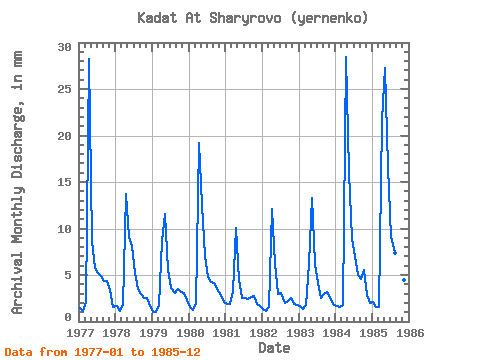
| Point ID: 8528 | Downloads | Plots | Site Data | Code: 10611 |
| Download | |
|---|---|
| Site Descriptor Information | Site Time Series Data |
| Link to all available data | |

|

|
| View: | Statistics | Time Series |
| Units: | m3/s |
| Statistic | Jan | Feb | Mar | Apr | May | Jun | Jul | Aug | Sep | Oct | Nov | Dec | Annual |
|---|---|---|---|---|---|---|---|---|---|---|---|---|---|
| Mean | 1.64 | 1.25 | 2.01 | 16.47 | 12.51 | 7.05 | 5.11 | 4.00 | 4.08 | 4.04 | 2.83 | 2.06 | 63.05 |
| Standard Deviation | 0.34 | 0.25 | 0.56 | 8.29 | 6.95 | 4.15 | 2.13 | 1.75 | 2.19 | 1.78 | 0.78 | 0.44 | 24.58 |
| Min | 1.00 | 0.97 | 1.57 | 6.20 | 4.56 | 2.48 | 2.56 | 2.06 | 2.21 | 2.56 | 1.93 | 1.64 | 38.54 |
| Max | 2.14 | 1.75 | 3.42 | 28.40 | 28.13 | 16.61 | 9.40 | 7.62 | 9.51 | 7.98 | 4.48 | 3.06 | 113.45 |
| Coefficient of Variation | 0.20 | 0.20 | 0.28 | 0.50 | 0.56 | 0.59 | 0.42 | 0.44 | 0.54 | 0.44 | 0.28 | 0.21 | 0.39 |
| Year | Jan | Feb | Mar | Apr | May | Jun | Jul | Aug | Sep | Oct | Nov | Dec | Annual | 1977 | 1.50 | 1.04 | 2.14 | 28.20 | 8.97 | 5.79 | 5.34 | 5.06 | 4.34 | 4.49 | 3.38 | 1.64 | 72.05 | 1978 | 1.71 | 1.10 | 1.85 | 13.72 | 9.40 | 8.07 | 5.41 | 3.63 | 2.96 | 2.56 | 2.55 | 1.71 | 54.70 | 1979 | 1.00 | 0.97 | 1.85 | 8.62 | 11.89 | 5.51 | 3.70 | 3.13 | 3.45 | 3.28 | 3.10 | 2.35 | 48.75 | 1980 | 1.64 | 1.17 | 1.99 | 19.16 | 12.96 | 7.03 | 4.91 | 4.34 | 4.14 | 3.63 | 2.83 | 2.21 | 66.03 | 1981 | 1.99 | 1.75 | 3.42 | 10.06 | 4.56 | 2.48 | 2.56 | 2.49 | 2.62 | 2.85 | 1.93 | 1.78 | 38.54 | 1982 | 1.35 | 1.10 | 1.57 | 12.13 | 6.34 | 2.96 | 3.13 | 2.06 | 2.21 | 2.63 | 1.93 | 1.85 | 39.31 | 1983 | 1.71 | 1.30 | 1.85 | 6.20 | 13.75 | 6.13 | 4.27 | 2.56 | 2.96 | 3.28 | 2.48 | 1.92 | 48.26 | 1984 | 1.71 | 1.43 | 1.85 | 28.40 | 16.59 | 8.82 | 7.26 | 5.13 | 4.55 | 5.70 | 2.83 | 2.06 | 86.38 | 1985 | 2.14 | 1.43 | 1.57 | 21.71 | 28.13 | 16.61 | 9.40 | 7.62 | 9.51 | 7.98 | 4.48 | 3.06 | 113.45 |
|---|
 Return to R-Arctic Net Home Page