|
|
|||||||||||||||||
| Point ID: 8389 | Downloads | Plots | Site Data | Code: 9478 |
|
|
|||||||||||||||||
| Download | |
|---|---|
| Site Descriptor Information | Site Time Series Data |
| Link to all available data | |
| View: | Time Series | All |
| Units: | m3/s |
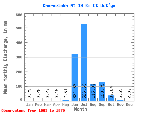
| Statistic | Jan | Feb | Mar | Apr | May | Jun | Jul | Aug | Sep | Oct | Nov | Dec | Annual |
|---|---|---|---|---|---|---|---|---|---|---|---|---|---|
| Mean | 0.79 | 0.28 | 0.28 | 0.15 | 7.51 | 321.59 | 526.54 | 115.05 | 128.75 | 37.64 | 5.69 | 2.07 | 1159.97 |
| Standard Deviation | 1.13 | 0.50 | 0.52 | 0.30 | 12.19 | 165.92 | 232.41 | 75.24 | 69.40 | 46.16 | 3.05 | 2.08 | 225.16 |
| Min | 0.00 | 0.00 | 0.00 | 0.00 | 0.00 | 125.03 | 244.70 | 30.14 | 68.10 | 6.93 | 2.74 | 0.12 | 935.56 |
| Max | 3.15 | 1.24 | 1.36 | 0.79 | 34.55 | 619.03 | 940.98 | 269.90 | 233.79 | 148.08 | 11.59 | 6.62 | 1548.17 |
| Coefficient of Variation | 1.43 | 1.75 | 1.91 | 1.96 | 1.62 | 0.52 | 0.44 | 0.65 | 0.54 | 1.23 | 0.54 | 1.01 | 0.19 |
 Return to R-Arctic Net Home Page