|
|
|||||||||||||||||
| Point ID: 8389 | Downloads | Plots | Site Data | Code: 9478 |
|
|
|||||||||||||||||
| Download | |
|---|---|
| Site Descriptor Information | Site Time Series Data |
| Link to all available data | |
|
|
| View: | Statistics | Time Series |
| Units: | m3/s |
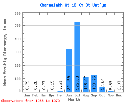
| Statistic | Jan | Feb | Mar | Apr | May | Jun | Jul | Aug | Sep | Oct | Nov | Dec | Annual |
|---|---|---|---|---|---|---|---|---|---|---|---|---|---|
| Mean | 0.79 | 0.28 | 0.28 | 0.15 | 7.51 | 321.59 | 526.54 | 115.05 | 128.75 | 37.64 | 5.69 | 2.07 | 1159.97 |
| Standard Deviation | 1.13 | 0.50 | 0.52 | 0.30 | 12.19 | 165.92 | 232.41 | 75.24 | 69.40 | 46.16 | 3.05 | 2.08 | 225.16 |
| Min | 0.00 | 0.00 | 0.00 | 0.00 | 0.00 | 125.03 | 244.70 | 30.14 | 68.10 | 6.93 | 2.74 | 0.12 | 935.56 |
| Max | 3.15 | 1.24 | 1.36 | 0.79 | 34.55 | 619.03 | 940.98 | 269.90 | 233.79 | 148.08 | 11.59 | 6.62 | 1548.17 |
| Coefficient of Variation | 1.43 | 1.75 | 1.91 | 1.96 | 1.62 | 0.52 | 0.44 | 0.65 | 0.54 | 1.23 | 0.54 | 1.01 | 0.19 |
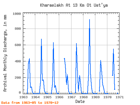
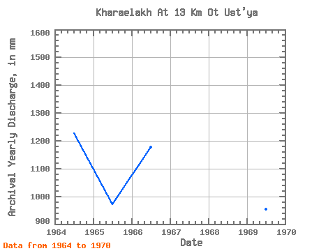
| Year | Jan | Feb | Mar | Apr | May | Jun | Jul | Aug | Sep | Oct | Nov | Dec | Annual | 1963 | 1.79 | 362.88 | 447.38 | 80.66 | 85.99 | 18.69 | 6.81 | 3.15 | 1964 | 1.26 | 0.70 | 0.56 | 0.28 | 4.73 | 146.37 | 693.13 | 168.03 | 169.75 | 43.90 | 8.23 | 1.68 | 1227.07 | 1965 | 0.03 | 0.00 | 0.00 | 0.00 | 1.57 | 125.03 | 650.07 | 80.44 | 101.04 | 20.79 | 2.74 | 0.12 | 971.70 | 1966 | 0.00 | 0.00 | 0.00 | 0.00 | 0.00 | 430.98 | 358.12 | 116.57 | 233.79 | 33.82 | 4.17 | 0.50 | 1178.63 | 1967 | 0.23 | 0.00 | 0.00 | 0.00 | 16.38 | 619.03 | 244.70 | 30.14 | 222.61 | 148.08 | 11.59 | 6.62 | 1303.88 | 1968 | 3.15 | 1.24 | 1.36 | 0.79 | 1.05 | 252.09 | 940.98 | 269.90 | 73.39 | 14.81 | 5.18 | 1.36 | 1548.17 | 1969 | 0.20 | 0.04 | 0.00 | 0.00 | 34.55 | 408.62 | 308.76 | 116.57 | 75.32 | 6.93 | 2.74 | 2.31 | 954.77 | 1970 | 0.66 | 0.00 | 0.00 | 0.00 | 0.00 | 227.69 | 569.21 | 58.08 | 68.10 | 14.07 | 4.07 | 0.81 | 935.56 |
|---|
 Return to R-Arctic Net Home Page