|
|
|||||||||||||||||
| Point ID: 8087 | Downloads | Plots | Site Data | Code: 1512 |
|
|
|||||||||||||||||
| Download | |
|---|---|
| Site Descriptor Information | Site Time Series Data |
| Link to all available data | |
| View: | Time Series | All |
| Units: | m3/s |
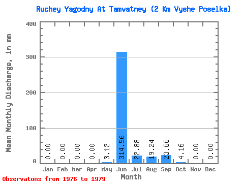
| Statistic | Jan | Feb | Mar | Apr | May | Jun | Jul | Aug | Sep | Oct | Nov | Dec | Annual |
|---|---|---|---|---|---|---|---|---|---|---|---|---|---|
| Mean | 0.00 | 0.00 | 0.00 | 0.00 | 3.25 | 314.51 | 22.62 | 19.06 | 23.48 | 4.29 | 0.00 | 0.00 | 391.23 |
| Standard Deviation | 0.00 | 0.00 | 0.00 | 0.00 | 3.90 | 105.11 | 14.77 | 16.44 | 13.26 | 3.46 | 0.00 | 0.00 | 118.36 |
| Min | 0.00 | 0.00 | 0.00 | 0.00 | 0.00 | 187.23 | 8.32 | 2.39 | 4.33 | 0.00 | 0.00 | 0.00 | 275.26 |
| Max | 0.00 | 0.00 | 0.00 | 0.00 | 7.80 | 443.21 | 40.56 | 35.88 | 34.73 | 7.80 | 0.00 | 0.00 | 538.56 |
| Coefficient of Variation | 1.20 | 0.33 | 0.65 | 0.86 | 0.56 | 0.81 | 0.30 |
 Return to R-Arctic Net Home Page