|
|
|||||||||||||||||
| Point ID: 7934 | Downloads | Plots | Site Data | Code: 3547 |
|
|
|||||||||||||||||
| Download | |
|---|---|
| Site Descriptor Information | Site Time Series Data |
| Link to all available data | |
| View: | Time Series | All |
| Units: | m3/s |
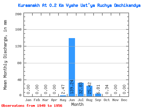
| Statistic | Jan | Feb | Mar | Apr | May | Jun | Jul | Aug | Sep | Oct | Nov | Dec | Annual |
|---|---|---|---|---|---|---|---|---|---|---|---|---|---|
| Mean | 0.00 | 0.00 | 0.00 | 0.00 | 2.48 | 139.24 | 32.82 | 25.41 | 6.81 | 0.34 | 0.00 | 0.00 | 208.14 |
| Standard Deviation | 0.00 | 0.00 | 0.00 | 0.00 | 5.84 | 34.82 | 27.39 | 14.02 | 6.09 | 0.64 | 0.00 | 0.00 | 63.99 |
| Min | 0.00 | 0.00 | 0.00 | 0.00 | 0.00 | 72.41 | 4.34 | 5.00 | 0.69 | 0.02 | 0.00 | 0.00 | 106.02 |
| Max | 0.00 | 0.00 | 0.00 | 0.00 | 16.82 | 186.37 | 74.81 | 48.69 | 17.05 | 1.90 | 0.00 | 0.00 | 300.65 |
| Coefficient of Variation | 2.36 | 0.25 | 0.83 | 0.55 | 0.90 | 1.86 | 0.31 |
 Return to R-Arctic Net Home Page