|
|
|||||||||||||||||
| Point ID: 7934 | Downloads | Plots | Site Data | Code: 3547 |
|
|
|||||||||||||||||
| Download | |
|---|---|
| Site Descriptor Information | Site Time Series Data |
| Link to all available data | |
|
|
| View: | Statistics | Time Series |
| Units: | m3/s |
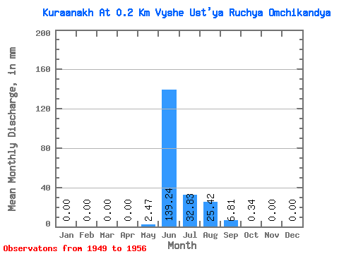
| Statistic | Jan | Feb | Mar | Apr | May | Jun | Jul | Aug | Sep | Oct | Nov | Dec | Annual |
|---|---|---|---|---|---|---|---|---|---|---|---|---|---|
| Mean | 0.00 | 0.00 | 0.00 | 0.00 | 2.48 | 139.24 | 32.82 | 25.41 | 6.81 | 0.34 | 0.00 | 0.00 | 208.14 |
| Standard Deviation | 0.00 | 0.00 | 0.00 | 0.00 | 5.84 | 34.82 | 27.39 | 14.02 | 6.09 | 0.64 | 0.00 | 0.00 | 63.99 |
| Min | 0.00 | 0.00 | 0.00 | 0.00 | 0.00 | 72.41 | 4.34 | 5.00 | 0.69 | 0.02 | 0.00 | 0.00 | 106.02 |
| Max | 0.00 | 0.00 | 0.00 | 0.00 | 16.82 | 186.37 | 74.81 | 48.69 | 17.05 | 1.90 | 0.00 | 0.00 | 300.65 |
| Coefficient of Variation | 2.36 | 0.25 | 0.83 | 0.55 | 0.90 | 1.86 | 0.31 |
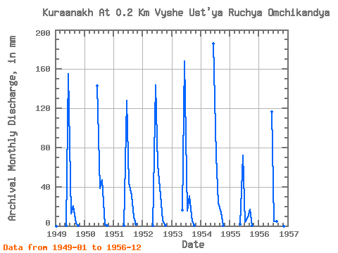
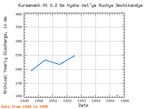
| Year | Jan | Feb | Mar | Apr | May | Jun | Jul | Aug | Sep | Oct | Nov | Dec | Annual | 1949 | 0.00 | 0.00 | 0.00 | 0.00 | 0.30 | 155.52 | 12.88 | 21.03 | 2.31 | 0.16 | 0.00 | 0.00 | 193.90 | 1950 | 0.00 | 0.00 | 0.00 | 0.00 | 0.00 | 143.10 | 39.35 | 48.69 | 1.20 | 0.02 | 0.00 | 0.00 | 232.90 | 1951 | 0.00 | 0.00 | 0.00 | 0.00 | 0.11 | 127.67 | 45.59 | 32.53 | 8.87 | 1.90 | 0.00 | 0.00 | 217.25 | 1952 | 0.00 | 0.00 | 0.00 | 0.00 | 0.49 | 143.95 | 64.63 | 31.91 | 5.44 | 0.14 | 0.00 | 0.00 | 247.01 | 1953 | 0.00 | 0.00 | 0.00 | 0.00 | 16.82 | 168.37 | 16.20 | 31.16 | 4.67 | 0.23 | 0.00 | 0.00 | 238.84 | 1954 | 0.00 | 0.00 | 0.00 | 0.00 | 0.00 | 186.37 | 74.81 | 23.99 | 14.22 | 0.09 | 0.00 | 0.00 | 300.65 | 1955 | 0.00 | 0.00 | 0.00 | 0.00 | 2.08 | 72.41 | 4.34 | 8.99 | 17.05 | 0.12 | 0.00 | 0.00 | 106.02 | 1956 | 0.00 | 0.00 | 0.00 | 0.00 | 0.00 | 116.53 | 4.78 | 5.00 | 0.69 | 0.05 | 0.00 | 0.00 | 128.59 |
|---|
 Return to R-Arctic Net Home Page