|
|
|||||||||||||||||
| Point ID: 7707 | Downloads | Plots | Site Data | Code: 15564900 |
|
|
|||||||||||||||||
| Download | |
|---|---|
| Site Descriptor Information | Site Time Series Data |
| Link to all available data | |
| View: | Time Series | All |
| Units: | m3/s |
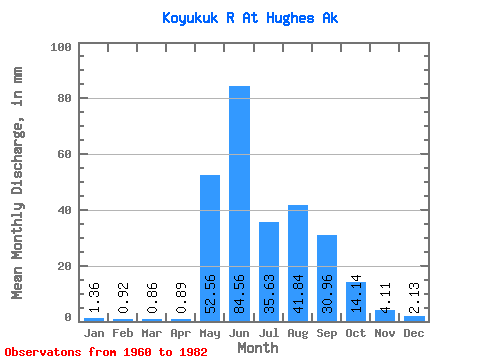
| Statistic | Jan | Feb | Mar | Apr | May | Jun | Jul | Aug | Sep | Oct | Nov | Dec | Annual |
|---|---|---|---|---|---|---|---|---|---|---|---|---|---|
| Mean | 1.36 | 0.93 | 0.86 | 0.89 | 52.55 | 84.56 | 35.62 | 41.83 | 30.96 | 14.13 | 4.11 | 2.13 | 268.24 |
| Standard Deviation | 0.53 | 0.35 | 0.35 | 0.38 | 21.15 | 38.58 | 15.30 | 25.27 | 17.60 | 10.25 | 2.46 | 1.16 | 73.87 |
| Min | 0.48 | 0.36 | 0.40 | 0.45 | 1.20 | 19.34 | 8.78 | 13.83 | 8.07 | 3.51 | 1.10 | 0.61 | 107.48 |
| Max | 2.18 | 1.74 | 1.83 | 1.88 | 84.00 | 156.63 | 66.36 | 118.98 | 74.17 | 47.12 | 12.73 | 6.09 | 411.28 |
| Coefficient of Variation | 0.39 | 0.38 | 0.41 | 0.42 | 0.40 | 0.46 | 0.43 | 0.60 | 0.57 | 0.72 | 0.60 | 0.55 | 0.28 |
 Return to R-Arctic Net Home Page