|
|
|||||||||||||||||
| Point ID: 7707 | Downloads | Plots | Site Data | Code: 15564900 |
|
|
|||||||||||||||||
| Download | |
|---|---|
| Site Descriptor Information | Site Time Series Data |
| Link to all available data | |
| View: | Time Series | All |
| Units: | mm |
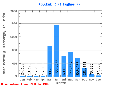
| Statistic | Jan | Feb | Mar | Apr | May | Jun | Jul | Aug | Sep | Oct | Nov | Dec | Annual |
|---|---|---|---|---|---|---|---|---|---|---|---|---|---|
| Mean | 24.17 | 18.13 | 15.28 | 16.37 | 935.23 | 1554.76 | 633.88 | 744.37 | 569.30 | 251.52 | 75.63 | 37.86 | 405.05 |
| Standard Deviation | 9.34 | 6.92 | 6.26 | 6.91 | 376.33 | 709.39 | 272.30 | 449.69 | 323.62 | 182.45 | 45.24 | 20.69 | 111.55 |
| Min | 8.49 | 7.08 | 7.08 | 8.21 | 21.29 | 355.66 | 156.17 | 246.16 | 148.29 | 62.38 | 20.19 | 10.82 | 162.30 |
| Max | 38.74 | 33.98 | 32.51 | 34.55 | 1494.85 | 2879.82 | 1180.81 | 2117.25 | 1363.74 | 838.46 | 234.09 | 108.42 | 621.04 |
| Coefficient of Variation | 0.39 | 0.38 | 0.41 | 0.42 | 0.40 | 0.46 | 0.43 | 0.60 | 0.57 | 0.72 | 0.60 | 0.55 | 0.28 |
 Return to R-Arctic Net Home Page