|
|
|||||||||||||||||
| Point ID: 7699 | Downloads | Plots | Site Data | Code: 15481000 |
|
|
|||||||||||||||||
| Download | |
|---|---|
| Site Descriptor Information | Site Time Series Data |
| Link to all available data | |
| View: | Time Series | All |
| Units: | m3/s |
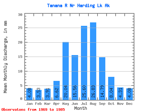
| Statistic | Jan | Feb | Mar | Apr | May | Jun | Jul | Aug | Sep | Oct | Nov | Dec | Annual |
|---|---|---|---|---|---|---|---|---|---|---|---|---|---|
| Mean | 4.08 | 3.56 | 3.91 | 6.62 | 20.03 | 15.56 | 25.59 | 26.82 | 14.79 | 8.04 | 4.31 | 4.08 | 188.57 |
| Standard Deviation | 0.00 | 0.00 | 0.00 | 0.40 | 0.01 | 14.19 | 23.34 | 24.47 | 12.79 | 0.00 | 0.00 | 0.00 | 0.00 |
| Min | 4.08 | 3.56 | 3.91 | 6.39 | 20.02 | 0.02 | 0.02 | 0.02 | 0.02 | 8.04 | 4.31 | 4.08 | 188.57 |
| Max | 4.08 | 3.56 | 3.91 | 7.09 | 20.04 | 26.10 | 42.80 | 44.75 | 22.18 | 8.04 | 4.31 | 4.08 | 188.57 |
| Coefficient of Variation | 0.00 | 0.00 | 0.00 | 0.06 | 0.00 | 0.91 | 0.91 | 0.91 | 0.86 | 0.00 | 0.00 | 0.00 | 0.00 |
 Return to R-Arctic Net Home Page