|
|
|||||||||||||||||
| Point ID: 7699 | Downloads | Plots | Site Data | Code: 15481000 |
|
|
|||||||||||||||||
| Download | |
|---|---|
| Site Descriptor Information | Site Time Series Data |
| Link to all available data | |
| View: | Time Series | All |
| Units: | mm |
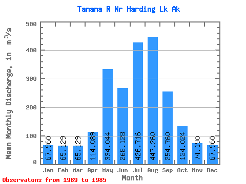
| Statistic | Jan | Feb | Mar | Apr | May | Jun | Jul | Aug | Sep | Oct | Nov | Dec | Annual |
|---|---|---|---|---|---|---|---|---|---|---|---|---|---|
| Mean | 67.96 | 65.13 | 65.13 | 114.09 | 334.04 | 268.13 | 426.72 | 447.26 | 254.76 | 134.02 | 74.19 | 67.96 | 266.79 |
| Standard Deviation | 0.01 | 0.01 | 0.01 | 6.96 | 0.17 | 244.46 | 389.20 | 407.98 | 220.38 | 0.04 | 0.01 | 0.01 | 0.00 |
| Min | 67.96 | 65.13 | 65.13 | 110.07 | 333.86 | 0.34 | 0.36 | 0.33 | 0.29 | 134.02 | 74.19 | 67.96 | 266.79 |
| Max | 67.96 | 65.13 | 65.13 | 122.13 | 334.14 | 449.67 | 713.59 | 746.15 | 381.99 | 134.02 | 74.19 | 67.96 | 266.79 |
| Coefficient of Variation | 0.00 | 0.00 | 0.00 | 0.06 | 0.00 | 0.91 | 0.91 | 0.91 | 0.86 | 0.00 | 0.00 | 0.00 | 0.00 |
 Return to R-Arctic Net Home Page