|
|
|||||||||||||||||
| Point ID: 7507 | Downloads | Plots | Site Data | Code: 70501 |
|
|
|||||||||||||||||
| Download | |
|---|---|
| Site Descriptor Information | Site Time Series Data |
| Link to all available data | |
| View: | Time Series | All |
| Units: | m3/s |
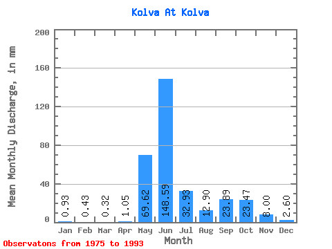
| Statistic | Jan | Feb | Mar | Apr | May | Jun | Jul | Aug | Sep | Oct | Nov | Dec | Annual |
|---|---|---|---|---|---|---|---|---|---|---|---|---|---|
| Mean | 0.93 | 0.43 | 0.32 | 1.04 | 69.61 | 148.59 | 32.93 | 12.90 | 23.89 | 23.46 | 8.00 | 2.60 | 347.08 |
| Standard Deviation | 0.47 | 0.26 | 0.15 | 1.59 | 66.42 | 70.37 | 23.81 | 11.27 | 16.59 | 13.78 | 4.39 | 1.24 | 67.77 |
| Min | 0.08 | 0.03 | 0.01 | 0.02 | 0.55 | 52.53 | 10.98 | 1.95 | 2.11 | 4.82 | 2.49 | 0.53 | 227.68 |
| Max | 1.71 | 1.06 | 0.60 | 5.91 | 202.63 | 304.13 | 119.08 | 47.85 | 57.02 | 46.60 | 16.64 | 4.73 | 450.90 |
| Coefficient of Variation | 0.50 | 0.59 | 0.46 | 1.52 | 0.95 | 0.47 | 0.72 | 0.87 | 0.69 | 0.59 | 0.55 | 0.47 | 0.20 |
 Return to R-Arctic Net Home Page