|
|
|||||||||||||||||
| Point ID: 7507 | Downloads | Plots | Site Data | Code: 70501 |
|
|
|||||||||||||||||
| Download | |
|---|---|
| Site Descriptor Information | Site Time Series Data |
| Link to all available data | |
| View: | Time Series | All |
| Units: | mm |
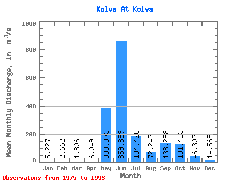
| Statistic | Jan | Feb | Mar | Apr | May | Jun | Jul | Aug | Sep | Oct | Nov | Dec | Annual |
|---|---|---|---|---|---|---|---|---|---|---|---|---|---|
| Mean | 5.23 | 2.66 | 1.81 | 6.05 | 389.87 | 859.89 | 184.43 | 72.25 | 138.26 | 131.43 | 46.31 | 14.57 | 164.96 |
| Standard Deviation | 2.60 | 1.58 | 0.83 | 9.20 | 372.04 | 407.21 | 133.35 | 63.10 | 95.99 | 77.18 | 25.39 | 6.93 | 32.21 |
| Min | 0.45 | 0.17 | 0.08 | 0.09 | 3.10 | 304.00 | 61.50 | 10.90 | 12.20 | 27.00 | 14.40 | 2.97 | 108.21 |
| Max | 9.59 | 6.55 | 3.37 | 34.20 | 1135.00 | 1760.00 | 667.00 | 268.00 | 330.00 | 261.00 | 96.30 | 26.50 | 214.31 |
| Coefficient of Variation | 0.50 | 0.59 | 0.46 | 1.52 | 0.95 | 0.47 | 0.72 | 0.87 | 0.69 | 0.59 | 0.55 | 0.47 | 0.20 |
 Return to R-Arctic Net Home Page