|
|
|||||||||||||||||
| Point ID: 7487 | Downloads | Plots | Site Data | Code: 70444 |
|
|
|||||||||||||||||
| Download | |
|---|---|
| Site Descriptor Information | Site Time Series Data |
| Link to all available data | |
| View: | Time Series | All |
| Units: | m3/s |
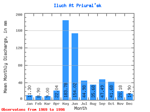
| Statistic | Jan | Feb | Mar | Apr | May | Jun | Jul | Aug | Sep | Oct | Nov | Dec | Annual |
|---|---|---|---|---|---|---|---|---|---|---|---|---|---|
| Mean | 11.30 | 8.98 | 9.00 | 22.04 | 183.76 | 154.02 | 44.97 | 35.67 | 47.49 | 41.68 | 20.18 | 14.90 | 592.61 |
| Standard Deviation | 1.58 | 1.24 | 1.10 | 27.01 | 59.67 | 80.50 | 19.86 | 18.96 | 34.44 | 14.55 | 5.72 | 2.59 | 85.84 |
| Min | 9.08 | 7.02 | 7.14 | 7.90 | 75.49 | 34.81 | 15.00 | 13.88 | 15.70 | 16.96 | 11.73 | 11.02 | 433.95 |
| Max | 15.02 | 11.71 | 11.78 | 129.35 | 278.00 | 291.29 | 88.25 | 76.00 | 202.92 | 76.77 | 31.60 | 21.65 | 755.89 |
| Coefficient of Variation | 0.14 | 0.14 | 0.12 | 1.23 | 0.33 | 0.52 | 0.44 | 0.53 | 0.72 | 0.35 | 0.28 | 0.17 | 0.14 |
 Return to R-Arctic Net Home Page