|
|
|||||||||||||||||
| Point ID: 7487 | Downloads | Plots | Site Data | Code: 70444 |
|
|
|||||||||||||||||
| Download | |
|---|---|
| Site Descriptor Information | Site Time Series Data |
| Link to all available data | |
| View: | Time Series | All |
| Units: | mm |
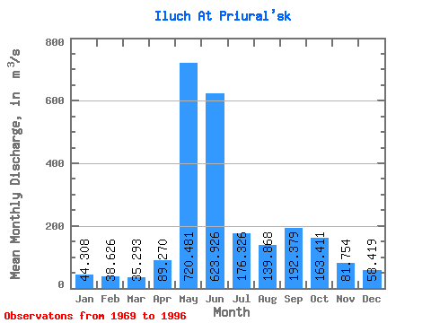
| Statistic | Jan | Feb | Mar | Apr | May | Jun | Jul | Aug | Sep | Oct | Nov | Dec | Annual |
|---|---|---|---|---|---|---|---|---|---|---|---|---|---|
| Mean | 44.31 | 38.63 | 35.29 | 89.27 | 720.48 | 623.93 | 176.33 | 139.87 | 192.38 | 163.41 | 81.75 | 58.42 | 197.16 |
| Standard Deviation | 6.18 | 5.35 | 4.32 | 109.42 | 233.95 | 326.10 | 77.87 | 74.34 | 139.49 | 57.06 | 23.19 | 10.15 | 28.56 |
| Min | 35.60 | 30.20 | 28.00 | 32.00 | 296.00 | 141.00 | 58.80 | 54.40 | 63.60 | 66.50 | 47.50 | 43.20 | 144.38 |
| Max | 58.90 | 50.40 | 46.20 | 524.00 | 1090.00 | 1180.00 | 346.00 | 298.00 | 822.00 | 301.00 | 128.00 | 84.90 | 251.48 |
| Coefficient of Variation | 0.14 | 0.14 | 0.12 | 1.23 | 0.33 | 0.52 | 0.44 | 0.53 | 0.72 | 0.35 | 0.28 | 0.17 | 0.14 |
 Return to R-Arctic Net Home Page