|
|
|||||||||||||||||
| Point ID: 7470 | Downloads | Plots | Site Data | Code: 70391 |
|
|
|||||||||||||||||
| Download | |
|---|---|
| Site Descriptor Information | Site Time Series Data |
| Link to all available data | |
| View: | Time Series | All |
| Units: | m3/s |
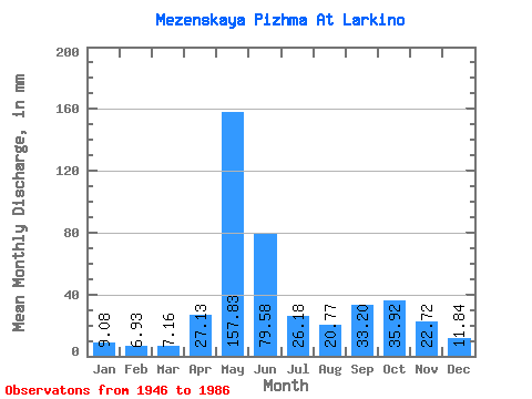
| Statistic | Jan | Feb | Mar | Apr | May | Jun | Jul | Aug | Sep | Oct | Nov | Dec | Annual |
|---|---|---|---|---|---|---|---|---|---|---|---|---|---|
| Mean | 9.08 | 6.99 | 7.16 | 27.13 | 157.80 | 79.58 | 26.18 | 20.77 | 33.20 | 35.92 | 22.72 | 11.84 | 438.07 |
| Standard Deviation | 2.72 | 1.62 | 1.16 | 35.47 | 47.63 | 50.79 | 12.71 | 10.66 | 16.32 | 16.33 | 15.41 | 5.54 | 67.91 |
| Min | 6.21 | 5.23 | 5.16 | 6.12 | 62.06 | 19.02 | 12.34 | 8.71 | 10.09 | 11.52 | 7.89 | 6.77 | 298.81 |
| Max | 22.67 | 14.32 | 11.79 | 141.54 | 261.40 | 227.35 | 65.99 | 55.66 | 73.87 | 75.68 | 82.45 | 42.32 | 578.19 |
| Coefficient of Variation | 0.30 | 0.23 | 0.16 | 1.31 | 0.30 | 0.64 | 0.49 | 0.51 | 0.49 | 0.46 | 0.68 | 0.47 | 0.15 |
 Return to R-Arctic Net Home Page