|
|
|||||||||||||||||
| Point ID: 7470 | Downloads | Plots | Site Data | Code: 70391 |
|
|
|||||||||||||||||
| Download | |
|---|---|
| Site Descriptor Information | Site Time Series Data |
| Link to all available data | |
| View: | Time Series | All |
| Units: | mm |
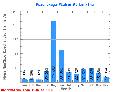
| Statistic | Jan | Feb | Mar | Apr | May | Jun | Jul | Aug | Sep | Oct | Nov | Dec | Annual |
|---|---|---|---|---|---|---|---|---|---|---|---|---|---|
| Mean | 9.94 | 8.40 | 7.83 | 30.66 | 172.65 | 89.96 | 28.64 | 22.72 | 37.53 | 39.30 | 25.68 | 12.95 | 40.67 |
| Standard Deviation | 2.98 | 1.94 | 1.26 | 40.09 | 52.12 | 57.41 | 13.91 | 11.66 | 18.45 | 17.87 | 17.42 | 6.07 | 6.30 |
| Min | 6.80 | 6.28 | 5.64 | 6.92 | 67.90 | 21.50 | 13.50 | 9.53 | 11.40 | 12.60 | 8.92 | 7.41 | 27.74 |
| Max | 24.80 | 17.20 | 12.90 | 160.00 | 286.00 | 257.00 | 72.20 | 60.90 | 83.50 | 82.80 | 93.20 | 46.30 | 53.68 |
| Coefficient of Variation | 0.30 | 0.23 | 0.16 | 1.31 | 0.30 | 0.64 | 0.49 | 0.51 | 0.49 | 0.46 | 0.68 | 0.47 | 0.15 |
 Return to R-Arctic Net Home Page