|
|
|||||||||||||||||
| Point ID: 7395 | Downloads | Plots | Site Data | Code: 70212 |
|
|
|||||||||||||||||
| Download | |
|---|---|
| Site Descriptor Information | Site Time Series Data |
| Link to all available data | |
| View: | Time Series | All |
| Units: | m3/s |
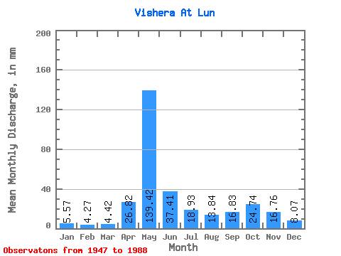
| Statistic | Jan | Feb | Mar | Apr | May | Jun | Jul | Aug | Sep | Oct | Nov | Dec | Annual |
|---|---|---|---|---|---|---|---|---|---|---|---|---|---|
| Mean | 5.57 | 4.31 | 4.42 | 26.82 | 139.40 | 37.41 | 18.92 | 13.83 | 16.84 | 24.74 | 16.76 | 8.07 | 315.01 |
| Standard Deviation | 1.43 | 0.84 | 0.69 | 32.00 | 41.29 | 18.58 | 13.71 | 9.82 | 13.72 | 13.30 | 8.64 | 2.64 | 59.98 |
| Min | 3.19 | 2.84 | 3.19 | 4.11 | 45.14 | 10.22 | 5.84 | 5.26 | 5.85 | 7.26 | 4.47 | 4.11 | 201.17 |
| Max | 10.62 | 6.68 | 6.31 | 140.93 | 212.47 | 98.23 | 77.39 | 45.48 | 80.49 | 76.37 | 37.12 | 16.19 | 460.37 |
| Coefficient of Variation | 0.26 | 0.20 | 0.16 | 1.19 | 0.30 | 0.50 | 0.72 | 0.71 | 0.81 | 0.54 | 0.52 | 0.33 | 0.19 |
 Return to R-Arctic Net Home Page