|
|
|||||||||||||||||
| Point ID: 7395 | Downloads | Plots | Site Data | Code: 70212 |
|
|
|||||||||||||||||
| Download | |
|---|---|
| Site Descriptor Information | Site Time Series Data |
| Link to all available data | |
| View: | Time Series | All |
| Units: | mm |
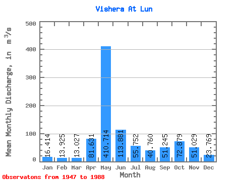
| Statistic | Jan | Feb | Mar | Apr | May | Jun | Jul | Aug | Sep | Oct | Nov | Dec | Annual |
|---|---|---|---|---|---|---|---|---|---|---|---|---|---|
| Mean | 16.41 | 13.93 | 13.03 | 81.63 | 410.71 | 113.88 | 55.75 | 40.76 | 51.24 | 72.88 | 51.03 | 23.77 | 78.75 |
| Standard Deviation | 4.21 | 2.72 | 2.04 | 97.41 | 121.65 | 56.56 | 40.38 | 28.94 | 41.77 | 39.17 | 26.30 | 7.77 | 14.99 |
| Min | 9.39 | 9.20 | 9.39 | 12.50 | 133.00 | 31.10 | 17.20 | 15.50 | 17.80 | 21.40 | 13.60 | 12.10 | 50.29 |
| Max | 31.30 | 21.60 | 18.60 | 429.00 | 626.00 | 299.00 | 228.00 | 134.00 | 245.00 | 225.00 | 113.00 | 47.70 | 115.09 |
| Coefficient of Variation | 0.26 | 0.20 | 0.16 | 1.19 | 0.30 | 0.50 | 0.72 | 0.71 | 0.81 | 0.54 | 0.52 | 0.33 | 0.19 |
 Return to R-Arctic Net Home Page