|
|
|||||||||||||||||
| Point ID: 6801 | Downloads | Plots | Site Data | Code: 10349 |
|
|
|||||||||||||||||
| Download | |
|---|---|
| Site Descriptor Information | Site Time Series Data |
| Link to all available data | |
| View: | Time Series | All |
| Units: | m3/s |
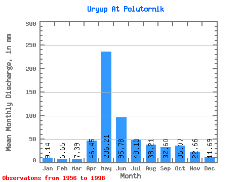
| Statistic | Jan | Feb | Mar | Apr | May | Jun | Jul | Aug | Sep | Oct | Nov | Dec | Annual |
|---|---|---|---|---|---|---|---|---|---|---|---|---|---|
| Mean | 9.14 | 6.71 | 7.39 | 46.45 | 236.17 | 95.78 | 48.12 | 38.21 | 32.60 | 36.07 | 22.66 | 11.69 | 582.99 |
| Standard Deviation | 6.15 | 5.55 | 5.61 | 51.06 | 65.53 | 50.24 | 50.77 | 36.72 | 18.89 | 18.46 | 12.37 | 5.51 | 170.46 |
| Min | 1.28 | 0.88 | 1.18 | 9.75 | 83.55 | 26.18 | 16.18 | 9.75 | 7.21 | 11.25 | 9.33 | 5.20 | 374.04 |
| Max | 35.24 | 33.18 | 30.64 | 295.49 | 421.52 | 222.91 | 333.68 | 234.59 | 104.72 | 99.09 | 60.65 | 30.42 | 1212.90 |
| Coefficient of Variation | 0.67 | 0.83 | 0.76 | 1.10 | 0.28 | 0.53 | 1.05 | 0.96 | 0.58 | 0.51 | 0.55 | 0.47 | 0.29 |
 Return to R-Arctic Net Home Page