|
|
|||||||||||||||||
| Point ID: 6801 | Downloads | Plots | Site Data | Code: 10349 |
|
|
|||||||||||||||||
| Download | |
|---|---|
| Site Descriptor Information | Site Time Series Data |
| Link to all available data | |
|
|
| View: | Statistics | Time Series |
| Units: | m3/s |
| Statistic | Jan | Feb | Mar | Apr | May | Jun | Jul | Aug | Sep | Oct | Nov | Dec | Annual |
|---|---|---|---|---|---|---|---|---|---|---|---|---|---|
| Mean | 9.14 | 6.71 | 7.39 | 46.45 | 236.17 | 95.78 | 48.12 | 38.21 | 32.60 | 36.07 | 22.66 | 11.69 | 582.99 |
| Standard Deviation | 6.15 | 5.55 | 5.61 | 51.06 | 65.53 | 50.24 | 50.77 | 36.72 | 18.89 | 18.46 | 12.37 | 5.51 | 170.46 |
| Min | 1.28 | 0.88 | 1.18 | 9.75 | 83.55 | 26.18 | 16.18 | 9.75 | 7.21 | 11.25 | 9.33 | 5.20 | 374.04 |
| Max | 35.24 | 33.18 | 30.64 | 295.49 | 421.52 | 222.91 | 333.68 | 234.59 | 104.72 | 99.09 | 60.65 | 30.42 | 1212.90 |
| Coefficient of Variation | 0.67 | 0.83 | 0.76 | 1.10 | 0.28 | 0.53 | 1.05 | 0.96 | 0.58 | 0.51 | 0.55 | 0.47 | 0.29 |
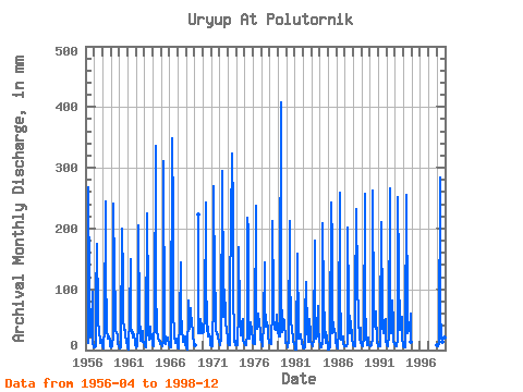
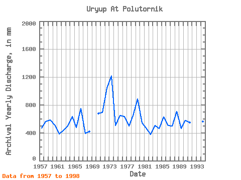
| Year | Jan | Feb | Mar | Apr | May | Jun | Jul | Aug | Sep | Oct | Nov | Dec | Annual | 1956 | 11.82 | 276.37 | 105.23 | 32.94 | 22.92 | 30.27 | 99.09 | 12.86 | 5.20 | 1957 | 5.41 | 3.51 | 7.28 | 77.76 | 179.96 | 62.21 | 51.58 | 30.15 | 17.63 | 11.25 | 17.32 | 8.03 | 469.67 | 1958 | 6.64 | 4.15 | 2.68 | 41.16 | 252.80 | 136.34 | 33.21 | 22.12 | 18.61 | 23.41 | 15.71 | 6.37 | 560.40 | 1959 | 5.95 | 4.29 | 5.89 | 25.19 | 249.59 | 128.56 | 65.34 | 32.78 | 29.19 | 23.46 | 12.23 | 7.28 | 585.96 | 1960 | 6.91 | 2.83 | 5.20 | 10.47 | 205.67 | 117.16 | 53.56 | 34.65 | 32.40 | 25.23 | 14.10 | 7.77 | 512.64 | 1961 | 4.82 | 1.07 | 4.07 | 54.95 | 154.79 | 34.89 | 32.46 | 20.78 | 29.34 | 25.23 | 14.31 | 7.66 | 381.93 | 1962 | 4.12 | 5.08 | 8.78 | 43.03 | 212.10 | 46.66 | 30.53 | 15.53 | 14.52 | 32.56 | 13.17 | 13.07 | 435.58 | 1963 | 6.70 | 5.56 | 4.29 | 13.01 | 232.45 | 87.09 | 28.92 | 18.43 | 39.19 | 28.33 | 26.54 | 10.71 | 498.18 | 1964 | 8.84 | 5.37 | 7.02 | 50.44 | 347.07 | 104.72 | 31.01 | 25.44 | 20.53 | 15.43 | 14.67 | 10.12 | 635.88 | 1965 | 11.46 | 8.35 | 6.16 | 13.12 | 321.90 | 30.33 | 16.18 | 10.28 | 20.22 | 20.41 | 19.65 | 7.71 | 480.55 | 1966 | 6.80 | 4.98 | 5.52 | 9.75 | 360.99 | 221.36 | 67.49 | 24.96 | 11.92 | 11.84 | 19.70 | 6.43 | 747.29 | 1967 | 5.46 | 4.64 | 2.73 | 46.55 | 149.97 | 60.13 | 37.97 | 14.35 | 17.52 | 22.87 | 21.57 | 7.50 | 389.45 | 1968 | 4.34 | 2.05 | 1.39 | 59.62 | 83.55 | 34.73 | 51.90 | 71.23 | 38.41 | 36.69 | 22.08 | 12.80 | 416.54 | 1969 | 8.68 | 222.91 | 27.80 | 31.23 | 27.63 | 53.24 | 35.98 | 28.17 | 1970 | 35.24 | 33.18 | 30.64 | 54.43 | 250.66 | 128.04 | 31.49 | 40.38 | 22.81 | 27.10 | 18.87 | 8.73 | 679.86 | 1971 | 6.91 | 5.76 | 7.55 | 83.46 | 278.51 | 105.23 | 86.77 | 34.55 | 25.30 | 26.94 | 21.67 | 13.66 | 692.06 | 1972 | 11.25 | 7.37 | 19.34 | 295.49 | 239.41 | 157.07 | 56.77 | 102.83 | 55.99 | 46.76 | 33.85 | 19.92 | 1045.69 | 1973 | 11.78 | 7.32 | 7.55 | 41.99 | 272.62 | 173.15 | 333.68 | 234.59 | 104.72 | 13.02 | 14.46 | 8.36 | 1212.90 | 1974 | 8.62 | 7.47 | 8.20 | 66.87 | 175.68 | 60.13 | 30.10 | 25.82 | 45.41 | 52.54 | 16.28 | 11.19 | 506.06 | 1975 | 10.61 | 7.91 | 9.11 | 25.25 | 225.49 | 196.99 | 23.51 | 18.96 | 35.25 | 46.70 | 34.01 | 15.43 | 647.82 | 1976 | 12.32 | 8.73 | 9.37 | 30.59 | 245.84 | 81.91 | 36.26 | 62.66 | 52.88 | 53.24 | 23.33 | 19.39 | 632.09 | 1977 | 13.39 | 9.22 | 7.12 | 45.31 | 149.43 | 69.47 | 50.77 | 39.85 | 46.24 | 35.94 | 23.12 | 12.05 | 499.81 | 1978 | 12.43 | 10.25 | 9.32 | 71.02 | 218.53 | 85.02 | 48.47 | 37.01 | 35.25 | 34.12 | 57.54 | 30.42 | 646.82 | 1979 | 29.73 | 20.50 | 22.92 | 94.87 | 421.52 | 102.64 | 29.78 | 43.28 | 51.01 | 48.63 | 16.90 | 11.25 | 887.62 | 1980 | 12.27 | 7.95 | 4.55 | 14.98 | 220.13 | 69.98 | 88.91 | 55.17 | 30.07 | 22.82 | 13.84 | 9.37 | 545.15 | 1981 | 5.73 | 1.17 | 1.18 | 158.63 | 156.40 | 37.84 | 18.59 | 22.76 | 26.02 | 25.92 | 9.90 | 8.46 | 471.82 | 1982 | 5.25 | 2.63 | 4.55 | 54.95 | 116.22 | 26.18 | 37.38 | 18.91 | 13.89 | 53.19 | 28.67 | 14.68 | 374.04 | 1983 | 10.87 | 6.98 | 6.91 | 16.43 | 185.85 | 86.05 | 20.09 | 21.32 | 21.98 | 75.52 | 37.43 | 16.44 | 502.75 | 1984 | 8.84 | 3.85 | 4.02 | 11.35 | 216.38 | 85.54 | 39.90 | 26.57 | 11.97 | 30.58 | 21.46 | 5.20 | 461.93 | 1985 | 1.28 | 0.88 | 5.78 | 15.86 | 250.66 | 172.63 | 27.91 | 47.08 | 36.96 | 34.06 | 23.38 | 12.85 | 626.26 | 1986 | 8.57 | 2.93 | 1.98 | 31.41 | 266.73 | 100.05 | 20.89 | 16.76 | 22.81 | 22.98 | 9.33 | 6.80 | 507.69 | 1987 | 6.37 | 6.93 | 6.91 | 10.94 | 207.81 | 76.20 | 40.65 | 27.91 | 43.13 | 48.85 | 20.48 | 8.25 | 500.96 | 1988 | 7.93 | 6.34 | 6.48 | 78.80 | 239.41 | 110.94 | 117.30 | 53.08 | 19.18 | 18.00 | 36.49 | 14.73 | 704.58 | 1989 | 7.66 | 6.64 | 8.46 | 21.10 | 265.12 | 80.35 | 22.34 | 9.75 | 7.21 | 20.84 | 10.63 | 8.30 | 464.51 | 1990 | 6.64 | 7.95 | 8.30 | 19.96 | 271.01 | 58.06 | 44.56 | 42.05 | 35.82 | 66.41 | 11.61 | 10.39 | 577.18 | 1991 | 6.27 | 7.12 | 5.73 | 30.74 | 217.45 | 58.06 | 41.35 | 28.12 | 35.35 | 49.81 | 51.74 | 17.30 | 545.62 | 1992 | 7.87 | 5.42 | 6.21 | 25.56 | 275.83 | 65.32 | 29.03 | 56.77 | 80.87 | 43.01 | 13.48 | 10.34 | 615.16 | 1993 | 7.34 | 6.20 | 5.78 | 18.87 | 260.30 | 129.08 | 36.85 | 33.74 | 51.06 | 56.24 | 16.64 | 9.69 | 628.10 | 1994 | 6.21 | 4.29 | 4.82 | 23.90 | 262.98 | 57.02 | 28.66 | 39.15 | 32.71 | 33.10 | 60.65 | 14.41 | 563.82 | 1998 | 9.05 | 8.00 | 7.12 | 12.08 | 293.51 | 65.84 | 22.07 | 14.30 | 12.65 | 27.42 | 20.89 | 11.03 | 499.33 |
|---|
 Return to R-Arctic Net Home Page