|
|
|||||||||||||||||
| Point ID: 6768 | Downloads | Plots | Site Data | Code: 10273 |
|
|
|||||||||||||||||
| Download | |
|---|---|
| Site Descriptor Information | Site Time Series Data |
| Link to all available data | |
| View: | Time Series | All |
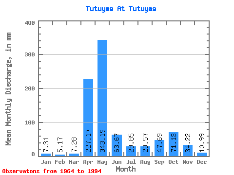
| Units: | m3/s |
| Statistic | Jan | Feb | Mar | Apr | May | Jun | Jul | Aug | Sep | Oct | Nov | Dec | Annual |
|---|---|---|---|---|---|---|---|---|---|---|---|---|---|
| Mean | 7.31 | 5.21 | 7.28 | 227.17 | 343.14 | 63.67 | 29.84 | 29.57 | 47.69 | 71.12 | 34.22 | 10.99 | 845.70 |
| Standard Deviation | 4.94 | 3.22 | 5.53 | 96.01 | 163.05 | 51.77 | 34.10 | 30.09 | 53.88 | 50.41 | 21.49 | 6.18 | 219.37 |
| Min | 2.26 | 1.83 | 1.50 | 30.25 | 121.16 | 11.97 | 4.43 | 5.51 | 3.64 | 6.85 | 6.63 | 3.09 | 502.45 |
| Max | 28.12 | 18.23 | 24.15 | 424.59 | 714.41 | 209.46 | 137.45 | 160.01 | 253.13 | 204.30 | 82.49 | 36.39 | 1411.26 |
| Coefficient of Variation | 0.68 | 0.62 | 0.76 | 0.42 | 0.47 | 0.81 | 1.14 | 1.02 | 1.13 | 0.71 | 0.63 | 0.56 | 0.26 |
 Return to R-Arctic Net Home Page