|
|
|||||||||||||||||
| Point ID: 6768 | Downloads | Plots | Site Data | Code: 10273 |
|
|
|||||||||||||||||
| Download | |
|---|---|
| Site Descriptor Information | Site Time Series Data |
| Link to all available data | |
|
|
| View: | Statistics | Time Series |
| Units: | m3/s |
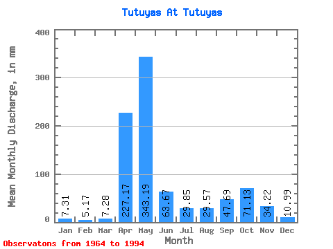
| Statistic | Jan | Feb | Mar | Apr | May | Jun | Jul | Aug | Sep | Oct | Nov | Dec | Annual |
|---|---|---|---|---|---|---|---|---|---|---|---|---|---|
| Mean | 7.31 | 5.21 | 7.28 | 227.17 | 343.14 | 63.67 | 29.84 | 29.57 | 47.69 | 71.12 | 34.22 | 10.99 | 845.70 |
| Standard Deviation | 4.94 | 3.22 | 5.53 | 96.01 | 163.05 | 51.77 | 34.10 | 30.09 | 53.88 | 50.41 | 21.49 | 6.18 | 219.37 |
| Min | 2.26 | 1.83 | 1.50 | 30.25 | 121.16 | 11.97 | 4.43 | 5.51 | 3.64 | 6.85 | 6.63 | 3.09 | 502.45 |
| Max | 28.12 | 18.23 | 24.15 | 424.59 | 714.41 | 209.46 | 137.45 | 160.01 | 253.13 | 204.30 | 82.49 | 36.39 | 1411.26 |
| Coefficient of Variation | 0.68 | 0.62 | 0.76 | 0.42 | 0.47 | 0.81 | 1.14 | 1.02 | 1.13 | 0.71 | 0.63 | 0.56 | 0.26 |
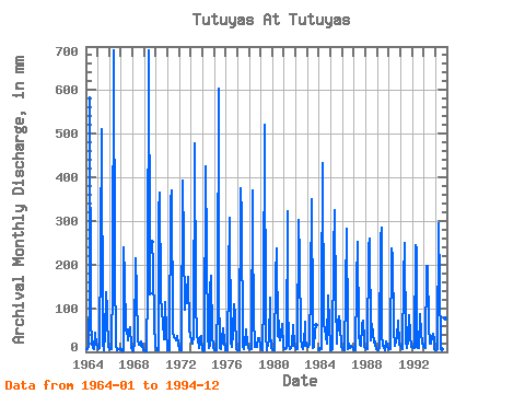
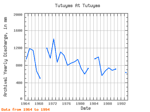
| Year | Jan | Feb | Mar | Apr | May | Jun | Jul | Aug | Sep | Oct | Nov | Dec | Annual | 1964 | 6.85 | 6.78 | 10.74 | 137.49 | 601.61 | 76.83 | 18.55 | 10.07 | 7.36 | 44.28 | 15.81 | 13.66 | 941.38 | 1965 | 10.53 | 5.67 | 9.73 | 241.00 | 526.41 | 20.10 | 4.43 | 40.15 | 137.49 | 103.61 | 82.49 | 11.36 | 1187.81 | 1966 | 7.02 | 4.80 | 7.39 | 160.94 | 714.41 | 192.88 | 18.68 | 15.17 | 4.89 | 6.85 | 6.63 | 10.32 | 1141.73 | 1967 | 3.97 | 2.21 | 2.76 | 239.39 | 177.14 | 48.52 | 52.64 | 27.99 | 46.50 | 57.24 | 11.65 | 3.09 | 672.52 | 1968 | 2.26 | 2.21 | 24.15 | 215.53 | 141.63 | 25.56 | 16.88 | 19.76 | 13.59 | 23.94 | 12.78 | 4.26 | 502.45 | 1969 | 3.51 | 1.83 | 1.50 | 147.59 | 714.41 | 209.46 | 137.45 | 253.13 | 204.30 | 60.25 | 15.83 | 1970 | 3.13 | 2.74 | 2.59 | 321.07 | 376.01 | 132.63 | 91.91 | 70.19 | 29.44 | 117.40 | 45.29 | 6.77 | 1195.15 | 1971 | 3.88 | 4.45 | 3.88 | 347.76 | 381.86 | 43.27 | 35.55 | 33.17 | 30.89 | 27.07 | 37.16 | 15.71 | 962.76 | 1972 | 5.89 | 3.84 | 3.47 | 392.24 | 256.94 | 97.45 | 115.31 | 160.01 | 112.41 | 176.31 | 54.59 | 36.39 | 1411.26 | 1973 | 28.12 | 18.23 | 23.65 | 30.25 | 492.99 | 120.50 | 35.68 | 30.58 | 9.30 | 35.39 | 35.95 | 18.51 | 871.51 | 1974 | 8.02 | 2.06 | 2.97 | 424.59 | 237.30 | 33.85 | 8.61 | 16.59 | 143.96 | 180.06 | 40.19 | 9.36 | 1108.83 | 1975 | 5.14 | 4.19 | 3.76 | 120.50 | 622.50 | 146.79 | 8.69 | 7.39 | 29.80 | 55.98 | 27.38 | 4.80 | 1029.31 | 1976 | 4.47 | 4.00 | 3.84 | 180.35 | 317.93 | 24.83 | 11.87 | 44.70 | 107.97 | 86.06 | 12.37 | 7.48 | 802.42 | 1977 | 4.55 | 2.44 | 2.84 | 374.85 | 322.53 | 13.71 | 7.77 | 21.77 | 17.83 | 52.22 | 19.57 | 8.52 | 847.51 | 1978 | 7.27 | 5.14 | 5.43 | 371.21 | 282.42 | 84.92 | 12.62 | 20.35 | 11.61 | 32.30 | 31.30 | 10.49 | 876.11 | 1979 | 6.85 | 5.03 | 4.64 | 118.08 | 538.94 | 38.94 | 5.01 | 19.64 | 24.46 | 128.26 | 45.69 | 9.53 | 936.01 | 1980 | 6.77 | 4.64 | 4.34 | 171.05 | 245.24 | 37.32 | 73.95 | 38.27 | 26.36 | 40.73 | 64.70 | 11.03 | 721.63 | 1981 | 6.94 | 5.52 | 8.65 | 321.88 | 121.16 | 17.31 | 6.31 | 7.98 | 14.68 | 64.76 | 13.46 | 11.07 | 601.45 | 1982 | 7.10 | 5.67 | 5.93 | 302.06 | 220.59 | 31.58 | 14.46 | 7.44 | 15.65 | 72.28 | 29.07 | 14.21 | 725.90 | 1983 | 12.24 | 10.70 | 18.30 | 149.21 | 362.22 | 77.64 | 9.61 | 11.53 | 46.91 | 63.92 | 1984 | 7.06 | 5.63 | 6.22 | 113.22 | 447.03 | 60.66 | 55.56 | 34.76 | 18.64 | 133.69 | 65.51 | 8.11 | 947.91 | 1985 | 3.55 | 2.82 | 5.22 | 228.06 | 336.73 | 116.46 | 18.93 | 76.04 | 47.72 | 84.39 | 63.89 | 12.16 | 993.25 | 1986 | 6.52 | 4.99 | 4.76 | 137.08 | 290.78 | 54.99 | 5.31 | 20.30 | 7.80 | 13.83 | 11.52 | 5.76 | 560.92 | 1987 | 3.05 | 3.27 | 4.76 | 156.90 | 261.53 | 43.27 | 17.71 | 13.24 | 60.25 | 72.69 | 25.64 | 10.86 | 670.75 | 1988 | 8.27 | 4.76 | 5.81 | 239.79 | 269.05 | 27.01 | 66.01 | 43.87 | 21.63 | 32.71 | 17.63 | 5.43 | 739.11 | 1989 | 5.47 | 4.04 | 9.78 | 262.84 | 294.54 | 39.22 | 15.75 | 8.48 | 3.64 | 24.77 | 14.19 | 7.31 | 688.48 | 1990 | 5.64 | 4.83 | 7.73 | 238.17 | 225.60 | 49.33 | 14.50 | 23.69 | 34.73 | 74.37 | 17.71 | 17.88 | 712.93 | 1991 | 15.29 | 9.10 | 6.27 | 165.79 | 257.36 | 23.74 | 10.19 | 28.24 | 31.95 | 86.90 | 39.67 | 11.99 | 683.55 | 1992 | 11.41 | 9.17 | 9.36 | 243.43 | 241.48 | 11.97 | 10.11 | 9.40 | 86.94 | 45.12 | 21.92 | 11.20 | 711.50 | 1993 | 12.20 | 7.46 | 9.23 | 195.71 | 203.04 | 59.44 | 18.93 | 20.72 | 33.20 | 42.61 | 25.68 | 5.85 | 633.66 | 1994 | 3.51 | 3.46 | 6.06 | 294.38 | 155.83 | 13.63 | 6.18 | 5.51 | 47.72 | 20.72 | 76.83 | 10.82 | 647.53 |
|---|
 Return to R-Arctic Net Home Page