|
|
|||||||||||||||||
| Point ID: 6762 | Downloads | Plots | Site Data | Other Close Sites | Code: 10251 |
|
|
|||||||||||||||||
| Download | |
|---|---|
| Site Descriptor Information | Site Time Series Data |
| Link to all available data | |
| View: | Time Series | All |
| Units: | m3/s |
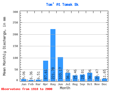
| Statistic | Jan | Feb | Mar | Apr | May | Jun | Jul | Aug | Sep | Oct | Nov | Dec | Annual |
|---|---|---|---|---|---|---|---|---|---|---|---|---|---|
| Mean | 9.05 | 6.42 | 6.51 | 87.61 | 221.75 | 103.17 | 36.31 | 25.46 | 28.81 | 36.06 | 20.47 | 11.65 | 591.06 |
| Standard Deviation | 4.00 | 2.53 | 2.33 | 45.27 | 66.73 | 50.04 | 17.49 | 10.48 | 14.01 | 14.92 | 11.65 | 4.98 | 109.99 |
| Min | 4.84 | 3.17 | 3.02 | 11.64 | 119.81 | 21.55 | 11.32 | 8.03 | 8.82 | 11.56 | 3.43 | 5.45 | 355.83 |
| Max | 26.07 | 18.41 | 15.69 | 204.63 | 382.44 | 247.38 | 100.07 | 66.25 | 71.85 | 76.58 | 67.30 | 30.77 | 844.09 |
| Coefficient of Variation | 0.44 | 0.39 | 0.36 | 0.52 | 0.30 | 0.48 | 0.48 | 0.41 | 0.49 | 0.41 | 0.57 | 0.43 | 0.19 |
| Other Close Sites | ||||||
|---|---|---|---|---|---|---|
| PointID | Latitude | Longitude | Drainage Area | Source | Name | |
| 6763 | "Tom' At Tomsk (Pristan')" | 56.50 | -325172 | SHI | 68.00 | |
 Return to R-Arctic Net Home Page