|
|
|||||||||||||||||
| Point ID: 6762 | Downloads | Plots | Site Data | Other Close Sites | Code: 10251 |
|
|
|||||||||||||||||
| Download | |
|---|---|
| Site Descriptor Information | Site Time Series Data |
| Link to all available data | |
| View: | Time Series | All |
| Units: | mm |
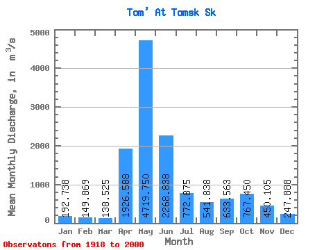
| Statistic | Jan | Feb | Mar | Apr | May | Jun | Jul | Aug | Sep | Oct | Nov | Dec | Annual |
|---|---|---|---|---|---|---|---|---|---|---|---|---|---|
| Mean | 192.74 | 149.87 | 138.53 | 1926.59 | 4719.75 | 2268.84 | 772.88 | 541.84 | 633.56 | 767.45 | 450.11 | 247.89 | 1067.50 |
| Standard Deviation | 85.15 | 59.03 | 49.54 | 995.54 | 1420.40 | 1100.50 | 372.28 | 223.09 | 308.11 | 317.49 | 256.18 | 105.99 | 198.65 |
| Min | 103.00 | 74.10 | 64.20 | 256.00 | 2550.00 | 474.00 | 241.00 | 171.00 | 194.00 | 246.00 | 75.40 | 116.00 | 642.67 |
| Max | 555.00 | 430.00 | 334.00 | 4500.00 | 8140.00 | 5440.00 | 2130.00 | 1410.00 | 1580.00 | 1630.00 | 1480.00 | 655.00 | 1524.50 |
| Coefficient of Variation | 0.44 | 0.39 | 0.36 | 0.52 | 0.30 | 0.48 | 0.48 | 0.41 | 0.49 | 0.41 | 0.57 | 0.43 | 0.19 |
| Other Close Sites | ||||||
|---|---|---|---|---|---|---|
| PointID | Latitude | Longitude | Drainage Area | Source | Name | |
| 6763 | "Tom' At Tomsk (Pristan')" | 56.50 | -325172 | SHI | 68.00 | |
 Return to R-Arctic Net Home Page