|
|
|||||||||||||||||
| Point ID: 6684 | Downloads | Plots | Site Data | Code: 10071 |
|
|
|||||||||||||||||
| Download | |
|---|---|
| Site Descriptor Information | Site Time Series Data |
| Link to all available data | |
| View: | Time Series | All |
| Units: | m3/s |
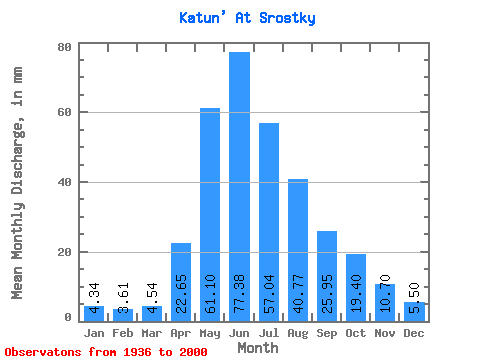
| Statistic | Jan | Feb | Mar | Apr | May | Jun | Jul | Aug | Sep | Oct | Nov | Dec | Annual |
|---|---|---|---|---|---|---|---|---|---|---|---|---|---|
| Mean | 4.34 | 3.64 | 4.54 | 22.65 | 61.09 | 77.38 | 57.03 | 40.77 | 25.95 | 19.40 | 10.70 | 5.50 | 333.01 |
| Standard Deviation | 1.98 | 1.76 | 1.90 | 7.63 | 13.88 | 22.41 | 16.65 | 10.86 | 8.35 | 6.55 | 3.66 | 2.38 | 59.50 |
| Min | 0.49 | 0.17 | 0.52 | 8.79 | 33.02 | 35.33 | 29.26 | 23.66 | 11.32 | 9.77 | 3.18 | 0.79 | 208.50 |
| Max | 10.04 | 7.14 | 8.85 | 44.21 | 98.13 | 130.04 | 122.44 | 74.75 | 53.70 | 42.46 | 21.04 | 10.87 | 491.05 |
| Coefficient of Variation | 0.46 | 0.48 | 0.42 | 0.34 | 0.23 | 0.29 | 0.29 | 0.27 | 0.32 | 0.34 | 0.34 | 0.43 | 0.18 |
 Return to R-Arctic Net Home Page