|
|
|||||||||||||||||
| Point ID: 6684 | Downloads | Plots | Site Data | Code: 10071 |
|
|
|||||||||||||||||
| Download | |
|---|---|
| Site Descriptor Information | Site Time Series Data |
| Link to all available data | |
| View: | Time Series | All |
| Units: | mm |
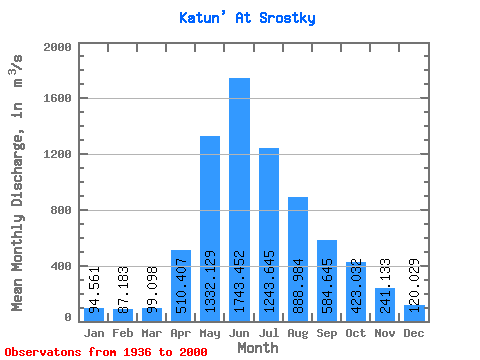
| Statistic | Jan | Feb | Mar | Apr | May | Jun | Jul | Aug | Sep | Oct | Nov | Dec | Annual |
|---|---|---|---|---|---|---|---|---|---|---|---|---|---|
| Mean | 94.56 | 87.18 | 99.10 | 510.41 | 1332.13 | 1743.45 | 1243.64 | 888.98 | 584.64 | 423.03 | 241.13 | 120.03 | 616.21 |
| Standard Deviation | 43.26 | 42.08 | 41.36 | 171.88 | 302.61 | 504.83 | 363.09 | 236.79 | 188.16 | 142.95 | 82.44 | 51.97 | 110.10 |
| Min | 10.60 | 4.07 | 11.30 | 198.00 | 720.00 | 796.00 | 638.00 | 516.00 | 255.00 | 213.00 | 71.70 | 17.30 | 385.82 |
| Max | 219.00 | 171.00 | 193.00 | 996.00 | 2140.00 | 2930.00 | 2670.00 | 1630.00 | 1210.00 | 926.00 | 474.00 | 237.00 | 908.67 |
| Coefficient of Variation | 0.46 | 0.48 | 0.42 | 0.34 | 0.23 | 0.29 | 0.29 | 0.27 | 0.32 | 0.34 | 0.34 | 0.43 | 0.18 |
 Return to R-Arctic Net Home Page