|
|
|||||||||||||||||
| Point ID: 6683 | Downloads | Plots | Site Data | Code: 10067 |
|
|
|||||||||||||||||
| Download | |
|---|---|
| Site Descriptor Information | Site Time Series Data |
| Link to all available data | |
| View: | Time Series | All |
| Units: | m3/s |
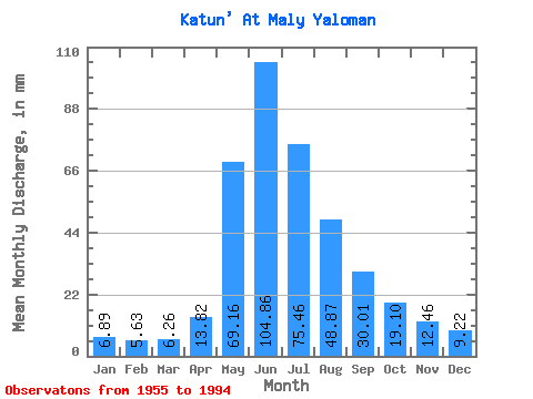
| Statistic | Jan | Feb | Mar | Apr | May | Jun | Jul | Aug | Sep | Oct | Nov | Dec | Annual |
|---|---|---|---|---|---|---|---|---|---|---|---|---|---|
| Mean | 6.89 | 5.68 | 6.26 | 13.82 | 69.15 | 104.86 | 75.45 | 48.87 | 30.01 | 19.10 | 12.46 | 9.22 | 407.16 |
| Standard Deviation | 2.45 | 1.75 | 1.24 | 4.11 | 17.00 | 38.59 | 23.12 | 11.00 | 8.59 | 4.70 | 2.52 | 3.34 | 80.69 |
| Min | 3.83 | 3.54 | 4.24 | 8.38 | 38.93 | 48.04 | 40.17 | 27.73 | 16.41 | 12.52 | 8.95 | 5.55 | 296.68 |
| Max | 12.52 | 9.48 | 8.44 | 24.93 | 90.97 | 183.84 | 113.52 | 67.75 | 46.42 | 28.02 | 16.48 | 16.37 | 524.40 |
| Coefficient of Variation | 0.36 | 0.31 | 0.20 | 0.30 | 0.25 | 0.37 | 0.31 | 0.23 | 0.29 | 0.25 | 0.20 | 0.36 | 0.20 |
 Return to R-Arctic Net Home Page