|
|
|||||||||||||||||
| Point ID: 6683 | Downloads | Plots | Site Data | Code: 10067 |
|
|
|||||||||||||||||
| Download | |
|---|---|
| Site Descriptor Information | Site Time Series Data |
| Link to all available data | |
| View: | Time Series | All |
| Units: | mm |
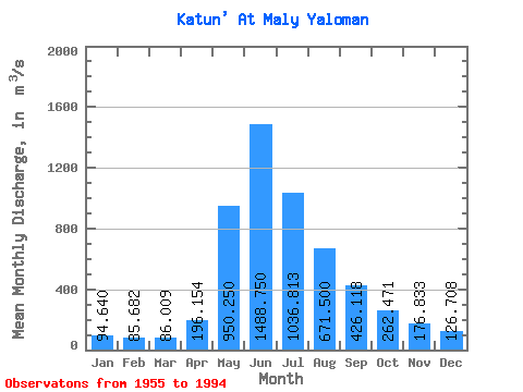
| Statistic | Jan | Feb | Mar | Apr | May | Jun | Jul | Aug | Sep | Oct | Nov | Dec | Annual |
|---|---|---|---|---|---|---|---|---|---|---|---|---|---|
| Mean | 94.64 | 85.68 | 86.01 | 196.15 | 950.25 | 1488.75 | 1036.81 | 671.50 | 426.12 | 262.47 | 176.83 | 126.71 | 474.76 |
| Standard Deviation | 33.72 | 26.41 | 17.07 | 58.34 | 233.63 | 547.86 | 317.73 | 151.13 | 121.98 | 64.63 | 35.80 | 45.90 | 94.08 |
| Min | 52.70 | 53.40 | 58.30 | 119.00 | 535.00 | 682.00 | 552.00 | 381.00 | 233.00 | 172.00 | 127.00 | 76.30 | 345.93 |
| Max | 172.00 | 143.00 | 116.00 | 354.00 | 1250.00 | 2610.00 | 1560.00 | 931.00 | 659.00 | 385.00 | 234.00 | 225.00 | 611.47 |
| Coefficient of Variation | 0.36 | 0.31 | 0.20 | 0.30 | 0.25 | 0.37 | 0.31 | 0.23 | 0.29 | 0.25 | 0.20 | 0.36 | 0.20 |
 Return to R-Arctic Net Home Page