|
|
|||||||||||||||||
| Point ID: 6682 | Downloads | Plots | Site Data | Code: 10066 |
|
|
|||||||||||||||||
| Download | |
|---|---|
| Site Descriptor Information | Site Time Series Data |
| Link to all available data | |
| View: | Time Series | All |
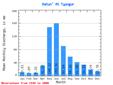
| Units: | m3/s |
| Statistic | Jan | Feb | Mar | Apr | May | Jun | Jul | Aug | Sep | Oct | Nov | Dec | Annual |
|---|---|---|---|---|---|---|---|---|---|---|---|---|---|
| Mean | 10.81 | 7.96 | 9.33 | 31.02 | 148.10 | 159.90 | 90.53 | 58.15 | 41.88 | 34.32 | 20.05 | 13.78 | 599.40 |
| Standard Deviation | 2.61 | 2.29 | 2.25 | 13.89 | 30.94 | 55.58 | 34.88 | 21.96 | 18.23 | 15.04 | 5.42 | 3.42 | 128.99 |
| Min | 5.43 | 3.42 | 4.36 | 13.59 | 52.17 | 57.60 | 39.28 | 28.76 | 1.72 | 17.81 | 11.87 | 8.43 | 383.22 |
| Max | 17.22 | 12.05 | 13.45 | 89.66 | 210.27 | 280.32 | 202.34 | 122.99 | 116.35 | 103.75 | 34.37 | 22.02 | 928.74 |
| Coefficient of Variation | 0.24 | 0.29 | 0.24 | 0.45 | 0.21 | 0.35 | 0.39 | 0.38 | 0.43 | 0.44 | 0.27 | 0.25 | 0.21 |
 Return to R-Arctic Net Home Page