|
|
|||||||||||||||||
| Point ID: 6682 | Downloads | Plots | Site Data | Code: 10066 |
|
|
|||||||||||||||||
| Download | |
|---|---|
| Site Descriptor Information | Site Time Series Data |
| Link to all available data | |
| View: | Time Series | All |
| Units: | mm |
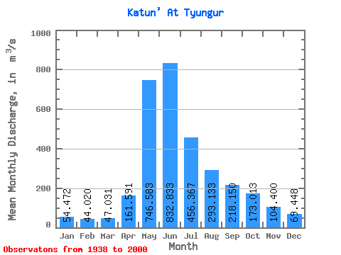
| Statistic | Jan | Feb | Mar | Apr | May | Jun | Jul | Aug | Sep | Oct | Nov | Dec | Annual |
|---|---|---|---|---|---|---|---|---|---|---|---|---|---|
| Mean | 54.47 | 44.02 | 47.03 | 161.59 | 746.58 | 832.83 | 456.37 | 293.13 | 218.15 | 173.01 | 104.40 | 69.45 | 256.40 |
| Standard Deviation | 13.15 | 12.65 | 11.36 | 72.34 | 155.96 | 289.47 | 175.84 | 110.70 | 94.93 | 75.79 | 28.25 | 17.22 | 55.17 |
| Min | 27.40 | 18.90 | 22.00 | 70.80 | 263.00 | 300.00 | 198.00 | 145.00 | 8.98 | 89.80 | 61.80 | 42.50 | 163.93 |
| Max | 86.80 | 66.70 | 67.80 | 467.00 | 1060.00 | 1460.00 | 1020.00 | 620.00 | 606.00 | 523.00 | 179.00 | 111.00 | 397.27 |
| Coefficient of Variation | 0.24 | 0.29 | 0.24 | 0.45 | 0.21 | 0.35 | 0.39 | 0.38 | 0.43 | 0.44 | 0.27 | 0.25 | 0.21 |
 Return to R-Arctic Net Home Page