|
|
|||||||||||||||||
| Point ID: 6643 | Downloads | Plots | Site Data | Code: 9500 |
|
|
|||||||||||||||||
| Download | |
|---|---|
| Site Descriptor Information | Site Time Series Data |
| Link to all available data | |
| View: | Time Series | All |
| Units: | m3/s |
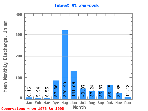
| Statistic | Jan | Feb | Mar | Apr | May | Jun | Jul | Aug | Sep | Oct | Nov | Dec | Annual |
|---|---|---|---|---|---|---|---|---|---|---|---|---|---|
| Mean | 8.15 | 5.99 | 6.55 | 87.36 | 320.36 | 131.09 | 48.86 | 37.23 | 35.87 | 65.14 | 27.85 | 11.18 | 781.54 |
| Standard Deviation | 1.83 | 1.37 | 1.82 | 51.16 | 85.06 | 53.97 | 25.28 | 25.24 | 20.56 | 47.26 | 13.36 | 4.08 | 148.68 |
| Min | 5.22 | 4.29 | 4.12 | 18.94 | 190.13 | 39.27 | 24.28 | 16.30 | 11.62 | 16.72 | 11.30 | 6.88 | 548.05 |
| Max | 11.25 | 8.97 | 10.06 | 207.03 | 458.36 | 226.34 | 110.34 | 105.25 | 77.64 | 178.25 | 50.53 | 20.67 | 987.44 |
| Coefficient of Variation | 0.22 | 0.23 | 0.28 | 0.59 | 0.27 | 0.41 | 0.52 | 0.68 | 0.57 | 0.73 | 0.48 | 0.36 | 0.19 |
 Return to R-Arctic Net Home Page