|
|
|||||||||||||||||
| Point ID: 6569 | Downloads | Plots | Site Data | Code: 9207 |
|
|
|||||||||||||||||
| Download | |
|---|---|
| Site Descriptor Information | Site Time Series Data |
| Link to all available data | |
| View: | Time Series | All |
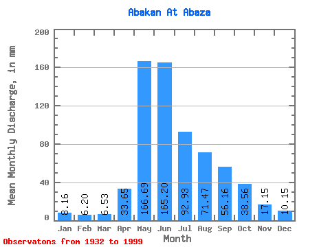
| Units: | m3/s |
| Statistic | Jan | Feb | Mar | Apr | May | Jun | Jul | Aug | Sep | Oct | Nov | Dec | Annual |
|---|---|---|---|---|---|---|---|---|---|---|---|---|---|
| Mean | 8.16 | 6.25 | 6.53 | 33.66 | 166.67 | 165.20 | 92.91 | 71.46 | 56.16 | 38.55 | 17.15 | 10.15 | 670.50 |
| Standard Deviation | 1.84 | 1.41 | 1.71 | 23.15 | 45.77 | 69.75 | 35.06 | 27.69 | 20.01 | 14.89 | 6.23 | 2.66 | 130.18 |
| Min | 3.09 | 2.52 | 2.49 | 6.80 | 46.68 | 50.22 | 39.43 | 24.36 | 16.09 | 14.04 | 7.33 | 3.87 | 419.52 |
| Max | 14.52 | 9.64 | 13.28 | 111.24 | 304.99 | 369.00 | 193.41 | 162.17 | 112.50 | 92.61 | 38.52 | 18.13 | 1159.74 |
| Coefficient of Variation | 0.23 | 0.23 | 0.26 | 0.69 | 0.28 | 0.42 | 0.38 | 0.39 | 0.36 | 0.39 | 0.36 | 0.26 | 0.19 |
 Return to R-Arctic Net Home Page