|
|
|||||||||||||||||
| Point ID: 6569 | Downloads | Plots | Site Data | Code: 9207 |
|
|
|||||||||||||||||
| Download | |
|---|---|
| Site Descriptor Information | Site Time Series Data |
| Link to all available data | |
| View: | Time Series | All |
| Units: | mm |
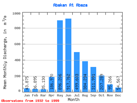
| Statistic | Jan | Feb | Mar | Apr | May | Jun | Jul | Aug | Sep | Oct | Nov | Dec | Annual |
|---|---|---|---|---|---|---|---|---|---|---|---|---|---|
| Mean | 43.88 | 36.90 | 35.13 | 186.97 | 896.21 | 917.76 | 499.60 | 384.23 | 311.99 | 207.29 | 95.27 | 54.57 | 305.93 |
| Standard Deviation | 9.89 | 8.34 | 9.22 | 128.61 | 246.09 | 387.53 | 188.51 | 148.91 | 111.18 | 80.06 | 34.59 | 14.32 | 59.40 |
| Min | 16.60 | 14.90 | 13.40 | 37.80 | 251.00 | 279.00 | 212.00 | 131.00 | 89.40 | 75.50 | 40.70 | 20.80 | 191.42 |
| Max | 78.10 | 56.90 | 71.40 | 618.00 | 1640.00 | 2050.00 | 1040.00 | 872.00 | 625.00 | 498.00 | 214.00 | 97.50 | 529.16 |
| Coefficient of Variation | 0.23 | 0.23 | 0.26 | 0.69 | 0.28 | 0.42 | 0.38 | 0.39 | 0.36 | 0.39 | 0.36 | 0.26 | 0.19 |
 Return to R-Arctic Net Home Page