|
|
|||||||||||||||||
| Point ID: 6555 | Downloads | Plots | Site Data | Other Close Sites | Code: 9127 |
|
|
|||||||||||||||||
| Download | |
|---|---|
| Site Descriptor Information | Site Time Series Data |
| Link to all available data | |
| View: | Time Series | All |
| Units: | m3/s |
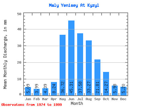
| Statistic | Jan | Feb | Mar | Apr | May | Jun | Jul | Aug | Sep | Oct | Nov | Dec | Annual |
|---|---|---|---|---|---|---|---|---|---|---|---|---|---|
| Mean | 5.09 | 4.03 | 4.39 | 8.24 | 36.71 | 45.31 | 37.57 | 33.26 | 21.81 | 14.27 | 5.97 | 5.20 | 220.92 |
| Standard Deviation | 1.00 | 0.67 | 0.80 | 2.75 | 10.24 | 14.40 | 11.99 | 10.12 | 5.32 | 2.98 | 1.38 | 1.04 | 34.90 |
| Min | 3.67 | 3.22 | 3.49 | 4.22 | 20.70 | 21.05 | 20.75 | 17.37 | 13.89 | 8.36 | 3.97 | 3.74 | 165.03 |
| Max | 6.81 | 5.37 | 6.12 | 16.06 | 57.12 | 74.31 | 61.24 | 60.32 | 35.74 | 21.07 | 10.79 | 7.50 | 264.33 |
| Coefficient of Variation | 0.20 | 0.17 | 0.18 | 0.33 | 0.28 | 0.32 | 0.32 | 0.30 | 0.24 | 0.21 | 0.23 | 0.20 | 0.16 |
| Other Close Sites | ||||||
|---|---|---|---|---|---|---|
| PointID | Latitude | Longitude | Drainage Area | Source | Name | |
| 6537 | "Yenisey at Kyizyil" | 51.72 | 320529 | SHI | 3486.00 | |
| 6548 | "Bol'shoy Yenisey At Kara-Khak" | 51.88 | 324040 | SHI | 20.00 | |
 Return to R-Arctic Net Home Page