|
|
|||||||||||||||||
| Point ID: 6548 | Downloads | Plots | Site Data | Other Close Sites | Code: 9116 |
|
|
|||||||||||||||||
| Download | |
|---|---|
| Site Descriptor Information | Site Time Series Data |
| Link to all available data | |
| View: | Time Series | All |
| Units: | m3/s |
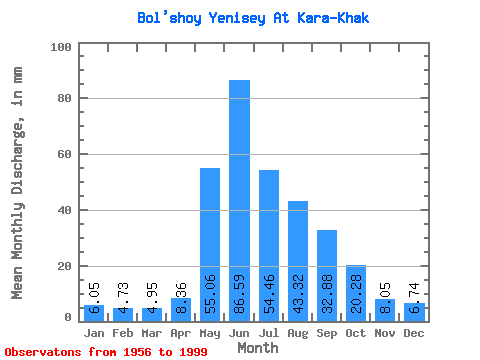
| Statistic | Jan | Feb | Mar | Apr | May | Jun | Jul | Aug | Sep | Oct | Nov | Dec | Annual |
|---|---|---|---|---|---|---|---|---|---|---|---|---|---|
| Mean | 6.05 | 4.77 | 4.95 | 8.36 | 55.05 | 86.59 | 54.46 | 43.32 | 32.88 | 20.27 | 8.05 | 6.74 | 330.43 |
| Standard Deviation | 1.15 | 1.17 | 1.47 | 3.84 | 14.88 | 25.20 | 16.07 | 12.50 | 8.12 | 4.86 | 1.80 | 1.31 | 52.49 |
| Min | 3.99 | 3.00 | 3.28 | 4.63 | 31.05 | 47.71 | 29.29 | 22.61 | 14.08 | 11.28 | 5.09 | 4.18 | 219.43 |
| Max | 8.77 | 7.34 | 8.82 | 22.52 | 91.48 | 155.52 | 84.37 | 72.99 | 50.92 | 39.62 | 12.52 | 10.19 | 464.84 |
| Coefficient of Variation | 0.19 | 0.24 | 0.30 | 0.46 | 0.27 | 0.29 | 0.29 | 0.29 | 0.25 | 0.24 | 0.22 | 0.20 | 0.16 |
| Other Close Sites | ||||||
|---|---|---|---|---|---|---|
| PointID | Latitude | Longitude | Drainage Area | Source | Name | |
| 6537 | "Yenisey at Kyizyil" | 51.72 | 320529 | SHI | 3486.00 | |
| 6555 | "Maly Yenisey At Kyzyl" | 51.72 | 327799 | SHI | 2.00 | |
 Return to R-Arctic Net Home Page