|
|
|||||||||||||||||
| Point ID: 6517 | Downloads | Plots | Site Data | Code: 8341 |
|
|
|||||||||||||||||
| Download | |
|---|---|
| Site Descriptor Information | Site Time Series Data |
| Link to all available data | |
| View: | Time Series | All |
| Units: | m3/s |
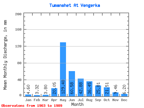
| Statistic | Jan | Feb | Mar | Apr | May | Jun | Jul | Aug | Sep | Oct | Nov | Dec | Annual |
|---|---|---|---|---|---|---|---|---|---|---|---|---|---|
| Mean | 4.60 | 3.35 | 3.79 | 20.05 | 129.38 | 60.59 | 42.87 | 36.44 | 25.81 | 21.50 | 9.46 | 6.20 | 362.48 |
| Standard Deviation | 1.24 | 0.85 | 1.28 | 16.81 | 39.94 | 26.72 | 19.62 | 22.28 | 9.04 | 10.68 | 3.02 | 1.57 | 75.76 |
| Min | 2.79 | 1.98 | 2.31 | 3.84 | 68.41 | 27.39 | 17.07 | 10.29 | 9.96 | 8.65 | 4.85 | 4.13 | 210.69 |
| Max | 8.65 | 6.18 | 7.37 | 62.25 | 224.53 | 135.82 | 102.33 | 114.60 | 44.77 | 55.31 | 16.24 | 10.12 | 506.62 |
| Coefficient of Variation | 0.27 | 0.26 | 0.34 | 0.84 | 0.31 | 0.44 | 0.46 | 0.61 | 0.35 | 0.50 | 0.32 | 0.25 | 0.21 |
 Return to R-Arctic Net Home Page