|
|
|||||||||||||||||
| Point ID: 6517 | Downloads | Plots | Site Data | Code: 8341 |
|
|
|||||||||||||||||
| Download | |
|---|---|
| Site Descriptor Information | Site Time Series Data |
| Link to all available data | |
| View: | Time Series | All |
| Units: | mm |
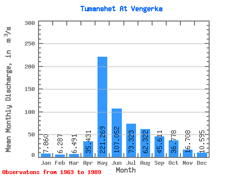
| Statistic | Jan | Feb | Mar | Apr | May | Jun | Jul | Aug | Sep | Oct | Nov | Dec | Annual |
|---|---|---|---|---|---|---|---|---|---|---|---|---|---|
| Mean | 7.86 | 6.29 | 6.49 | 35.43 | 221.27 | 107.05 | 73.32 | 62.32 | 45.61 | 36.78 | 16.71 | 10.60 | 52.60 |
| Standard Deviation | 2.12 | 1.60 | 2.19 | 29.70 | 68.30 | 47.21 | 33.56 | 38.10 | 15.97 | 18.26 | 5.34 | 2.69 | 10.99 |
| Min | 4.77 | 3.71 | 3.95 | 6.79 | 117.00 | 48.40 | 29.20 | 17.60 | 17.60 | 14.80 | 8.57 | 7.07 | 30.58 |
| Max | 14.80 | 11.60 | 12.60 | 110.00 | 384.00 | 240.00 | 175.00 | 196.00 | 79.10 | 94.60 | 28.70 | 17.30 | 73.52 |
| Coefficient of Variation | 0.27 | 0.26 | 0.34 | 0.84 | 0.31 | 0.44 | 0.46 | 0.61 | 0.35 | 0.50 | 0.32 | 0.25 | 0.21 |
 Return to R-Arctic Net Home Page