|
|
|||||||||||||||||
| Point ID: 6471 | Downloads | Plots | Site Data | Code: 8172 |
|
|
|||||||||||||||||
| Download | |
|---|---|
| Site Descriptor Information | Site Time Series Data |
| Link to all available data | |
| View: | Time Series | All |
| Units: | m3/s |
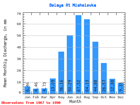
| Statistic | Jan | Feb | Mar | Apr | May | Jun | Jul | Aug | Sep | Oct | Nov | Dec | Annual |
|---|---|---|---|---|---|---|---|---|---|---|---|---|---|
| Mean | 6.46 | 4.49 | 4.73 | 13.09 | 36.15 | 50.29 | 67.51 | 64.12 | 44.88 | 26.57 | 12.88 | 9.14 | 338.61 |
| Standard Deviation | 1.22 | 1.04 | 0.99 | 3.55 | 9.32 | 13.03 | 17.77 | 15.67 | 11.14 | 3.73 | 2.52 | 1.49 | 43.22 |
| Min | 3.54 | 2.07 | 2.60 | 7.03 | 19.92 | 29.24 | 41.15 | 36.90 | 27.66 | 18.12 | 8.42 | 6.70 | 254.58 |
| Max | 8.74 | 6.81 | 6.50 | 19.12 | 61.89 | 79.81 | 113.49 | 101.73 | 70.33 | 33.15 | 18.49 | 12.31 | 437.35 |
| Coefficient of Variation | 0.19 | 0.23 | 0.21 | 0.27 | 0.26 | 0.26 | 0.26 | 0.24 | 0.25 | 0.14 | 0.20 | 0.16 | 0.13 |
 Return to R-Arctic Net Home Page