|
|
|||||||||||||||||
| Point ID: 6471 | Downloads | Plots | Site Data | Code: 8172 |
|
|
|||||||||||||||||
| Download | |
|---|---|
| Site Descriptor Information | Site Time Series Data |
| Link to all available data | |
| View: | Time Series | All |
| Units: | mm |
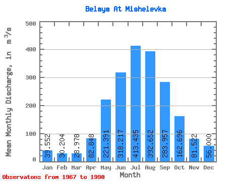
| Statistic | Jan | Feb | Mar | Apr | May | Jun | Jul | Aug | Sep | Oct | Nov | Dec | Annual |
|---|---|---|---|---|---|---|---|---|---|---|---|---|---|
| Mean | 39.55 | 30.20 | 28.98 | 82.85 | 221.39 | 318.22 | 413.44 | 392.65 | 283.96 | 162.70 | 81.52 | 56.00 | 175.95 |
| Standard Deviation | 7.44 | 6.99 | 6.06 | 22.49 | 57.05 | 82.47 | 108.82 | 95.97 | 70.51 | 22.85 | 15.97 | 9.11 | 22.46 |
| Min | 21.70 | 13.90 | 15.90 | 44.50 | 122.00 | 185.00 | 252.00 | 226.00 | 175.00 | 111.00 | 53.30 | 41.00 | 132.29 |
| Max | 53.50 | 45.80 | 39.80 | 121.00 | 379.00 | 505.00 | 695.00 | 623.00 | 445.00 | 203.00 | 117.00 | 75.40 | 227.27 |
| Coefficient of Variation | 0.19 | 0.23 | 0.21 | 0.27 | 0.26 | 0.26 | 0.26 | 0.24 | 0.25 | 0.14 | 0.20 | 0.16 | 0.13 |
 Return to R-Arctic Net Home Page