|
|
|||||||||||||||||
| Point ID: 6457 | Downloads | Plots | Site Data | Code: 8059 |
|
|
|||||||||||||||||
| Download | |
|---|---|
| Site Descriptor Information | Site Time Series Data |
| Link to all available data | |
| View: | Time Series | All |
| Units: | m3/s |
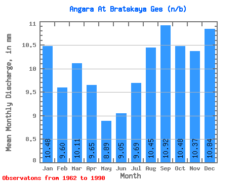
| Statistic | Jan | Feb | Mar | Apr | May | Jun | Jul | Aug | Sep | Oct | Nov | Dec | Annual |
|---|---|---|---|---|---|---|---|---|---|---|---|---|---|
| Mean | 10.48 | 9.68 | 10.11 | 9.65 | 8.89 | 9.05 | 9.68 | 10.45 | 10.92 | 10.48 | 10.37 | 10.84 | 120.67 |
| Standard Deviation | 2.70 | 2.75 | 2.80 | 2.42 | 1.87 | 1.36 | 1.59 | 2.35 | 2.49 | 2.26 | 2.56 | 2.52 | 21.19 |
| Min | 3.64 | 4.81 | 4.62 | 6.23 | 6.22 | 7.01 | 6.33 | 6.59 | 7.29 | 3.35 | 2.62 | 3.38 | 82.74 |
| Max | 14.30 | 14.22 | 14.59 | 14.40 | 12.84 | 12.08 | 12.95 | 17.54 | 18.14 | 14.48 | 13.52 | 15.03 | 157.80 |
| Coefficient of Variation | 0.26 | 0.28 | 0.28 | 0.25 | 0.21 | 0.15 | 0.16 | 0.23 | 0.23 | 0.21 | 0.25 | 0.23 | 0.18 |
 Return to R-Arctic Net Home Page